Kazarman geodata
Kazarman (Jalal-Abad) is a seat of a second-order administrative division; located in Kyrgyzstan in Asia/Bishkek (GMT+6) time zone. In our database, there are 37 cities with bigger population. Compared to other cities in Kyrgyzstan, 58.3% of cities are located further ↓South; 72.6% of cities are located further ←West and 65.5% of cities have lower elevation than Kazarman. Note1


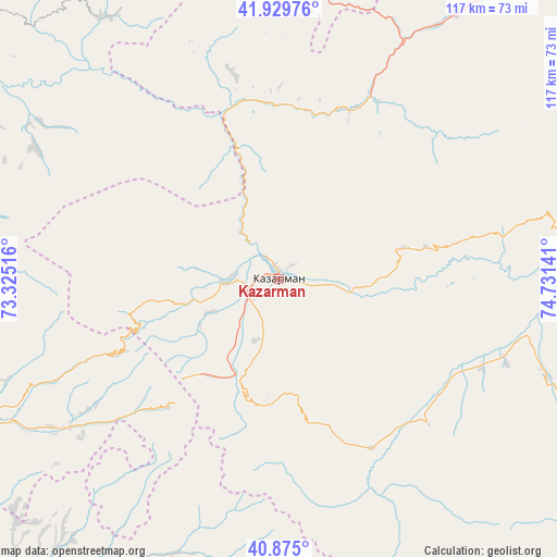
Kazarman GPS coordinates[2]
41° 24' 16.272" North, 74° 1' 41.808" East
| Map corner | latitude | longitude |
|---|---|---|
| Upper-left | 41.92976°, | 73.32516° |
| Center: | 41.40452°, | 74.02828° |
| Lower-right: | 40.875°, | 74.73141° |
| Map W x H: | 117.3×117.3 km | = 72.9×72.9mi |
| max Lat: | 42.89106° ⇑41.7% North |
| Kazarman: | 41.40452° |
| min Lat: | ⇓58.3% South 39.55274° |
| min Long | Kazarman | max Long |
| 69.3716° | 74.02828° | 78.52702° |
| W 72.6%⇐ | ⇒27.4% E |
Elevation
Elevation of Kazarman is 1269 m = 4163 ft, and this is 67.6 m = 222 ft above average elevation for this country.
| Max E: |
2638 m = 8655 ft | 34.5% |
| Kazarman | 1269 m 4163 ft | |
| Avg. | 1201.4 m = 3942 ft | |
Min E: |
504 m = 1654 ft | 65.5% |
See also: Kyrgyzstan elevation on elevation.city.
Geographical zone
Kazarman is located in North temperate zone (between Tropic of Cancer and the Arctic Circle). Distance of this Northern Tropic circle is 1997.8 km =1241.4 mi to South.| Distance of | km | miles | from Kazarman |
|---|---|---|---|
| North Pole | 5403.3 | 3357.5 | to North |
| Arctic Circle | 2797.4 | 1738.2 | to North |
| Tropic Cancer | 1997.8 | 1241.4 | to South |
| Equator | 4603.8 | 2860.7 | to South |


Nearby cities:
15 places around Kazarman: (largest is in red/bold)
• Baetovo
79 km =49.1 mi,  101°
101°
• Bazar-Korgon
114.7 km =71.3 mi,  249°
249°
• Chayek
70.9 km =44.1 mi,  34°
34°
• Gul’cha
130.8 km =81.3 mi,  202°
202°
• Jalal-Abad
100.8 km =62.6 mi,  238°
238°
• Kara Suu
124.7 km =77.5 mi,  231°
231°
• Kara-Kulja
93.3 km =58 mi, 203°
• Kochkor-Ata
135.5 km =84.2 mi, 252°
• Massy
122.8 km =76.3 mi, 251°
• Osh
142 km =88.2 mi, 226°
• Sosnovka
137.5 km =85.4 mi,  355°
355°
• Suzak
109.6 km =68.1 mi, 239°
• Toktogul
104.3 km =64.8 mi,  300°
300°
• Uzgen
93.3 km =58 mi,  220°
220°
• Üch-Terek
79.5 km =49.4 mi, 300°
Sources, notices
• [Note1] Compared only with cities in Kyrgyzstan existing in our database
• [Src1] Map data: © OpenStreetMap contributors (CC-BY-SA)
• [Src2] Other city data from geonames.org with taken over terms of usage.
• [Src3] Geographical zone / Annual Mean Temperature by Robert A. Rohde @ Wikipedia
