Chasŏng geodata
Chasŏng (Chagang-do) is a populated place; located in North Korea in Asia/Pyongyang (GMT+9) time zone. With population of 12,736 people, there are 65 cities with bigger population in this country. Compared to other cities in North Korea, 71.4% of cities are located further ↓South; 54.9% of cities are located further →East and 90.1% of cities have lower elevation than Chasŏng. Note1


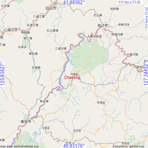
Chasŏng GPS coordinates[2]
41° 27' 38.988" North, 126° 38' 29.004" East
| Map corner | latitude | longitude |
|---|---|---|
| Upper-left | 41.98562°, | 125.93827° |
| Center: | 41.46083°, | 126.64139° |
| Lower-right: | 40.93176°, | 127.34452° |
| Map W x H: | 117.2×117.2 km | = 72.8×72.8mi |
| max Lat: | 42.95722° ⇑28.6% North |
| Chasŏng: | 41.46083° |
| min Lat: | ⇓71.4% South 37.90889° |
| min Long | Chasŏng | max Long |
| 124.39806° | 126.64139° | 130.49522° |
| W 45.1%⇐ | ⇒54.9% E |
Elevation
Elevation of Chasŏng is 328 m = 1076 ft, and this is 196.3 m = 644 ft above average elevation for this country.
| Max E: |
1466 m = 4810 ft | 9.9% |
| Chasŏng | 328 m 1076 ft | |
| Avg. | 131.7 m = 432 ft | |
Min E: |
1 m = 3 ft | 90.1% |
See also: North Korea elevation on elevation.city.
Geographical zone
Chasŏng is located in North temperate zone (between Tropic of Cancer and the Arctic Circle). Distance of this Northern Tropic circle is 2004.1 km =1245.3 mi to South.| Distance of | km | miles | from Chasŏng |
|---|---|---|---|
| North Pole | 5397 | 3353.5 | to North |
| Arctic Circle | 2791.2 | 1734.4 | to North |
| Tropic Cancer | 2004.1 | 1245.3 | to South |
| Equator | 4610 | 2864.5 | to South |


Nearby cities:
15 places around Chasŏng: (largest is in red/bold)
• Hamhŭng
187.4 km =116.4 mi,  156°
156°
• Hongwŏn
194.3 km =120.7 mi,  145°
145°
• Hyesan
128.2 km =79.7 mi,  92°
92°
• Hyesan-dong
128.4 km =79.8 mi, 93°
• Hŭngju-dong
52.2 km =32.4 mi,  188°
188°
• Kanggye
54.8 km =34.1 mi,  184°
184°
• Kapsan-ŭp
144.1 km =89.5 mi,  106°
106°
• Kujang-ŭp
184.5 km =114.6 mi,  196°
196°
• Manp’o
45 km =28 mi,  220°
220°
• Pukchil-lodongjagu
158.9 km =98.7 mi,  208°
208°
• Sakchu-ŭp
179.3 km =111.4 mi,  228°
228°
• Sŭngjibaegam
181.7 km =112.9 mi,  97°
97°
• Yŏngbyŏn
196.3 km =122 mi, 201°
• Yŏnggwang-ŭp
174.4 km =108.4 mi, 156°
• Ŭijin-dong
55.4 km =34.4 mi, 192°
Sources, notices
• [Note1] Compared only with cities in North Korea existing in our database
• [Src1] Map data: © OpenStreetMap contributors (CC-BY-SA)
• [Src2] Other city data from geonames.org with taken over terms of usage.
• [Src3] Geographical zone / Annual Mean Temperature by Robert A. Rohde @ Wikipedia
