Yeraliyev geodata
Yeraliyev (Mangghystaū) is a populated place; located in Kazakhstan in Asia/Aqtau (GMT+5) time zone. With population of 11,836 people, there are 98 cities with bigger population in this country. Compared to other cities in Kazakhstan, 88.5% of cities are located further ↑North; 93.3% of cities are located further →East and 95.2% of cities have higher elevation than Yeraliyev. Note1


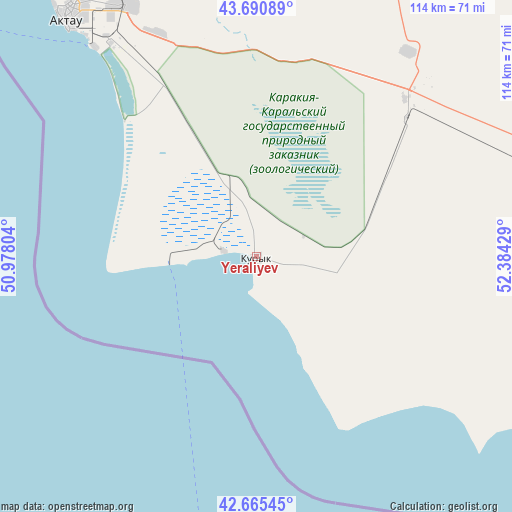
Yeraliyev GPS coordinates[2]
43° 10' 49.152" North, 51° 40' 52.176" East
| Map corner | latitude | longitude |
|---|---|---|
| Upper-left | 43.69089°, | 50.97804° |
| Center: | 43.18032°, | 51.68116° |
| Lower-right: | 42.66545°, | 52.38429° |
| Map W x H: | 114×114 km | = 70.8×70.8mi |
| max Lat: | 54.90596° ⇑88.5% North |
| Yeraliyev: | 43.18032° |
| min Lat: | ⇓11.5% South 40.66338° |
| min Long | Yeraliyev | max Long |
| 46.83361° | 51.68116° | 84.87144° |
| W 6.7%⇐ | ⇒93.3% E |
Elevation
Elevation of Yeraliyev is -11 m = -36 ft, and this is 367.5 m = 1206 ft below average elevation for this country.
| Max E: |
1847 m = 6060 ft | 95.2% |
| Avg. | 356.5 m = 1170 ft | |
| Yeraliyev | -11 m = -36 ft | |
Min E: |
-26 m = -85 ft | 4.8% |
See also: Kazakhstan elevation on elevation.city.
Geographical zone
Yeraliyev is located in North temperate zone (between Tropic of Cancer and the Arctic Circle). Distance of this Northern Tropic circle is 2195.3 km =1364.1 mi to South.| Distance of | km | miles | from Yeraliyev |
|---|---|---|---|
| North Pole | 5205.9 | 3234.8 | to North |
| Arctic Circle | 2600 | 1615.6 | to North |
| Tropic Cancer | 2195.3 | 1364.1 | to South |
| Equator | 4801.2 | 2983.3 | to South |


Nearby cities:
13 places around Yeraliyev: (largest is in red/bold)
• Aktau
66.7 km =41.4 mi,  321°
321°
• Atyrau
438 km =272.2 mi,  2°
2°
• Balykshi
432.4 km =268.7 mi, 1°
• Baūtīno
190.4 km =118.3 mi, 322°
• Fort-Shevchenko
186.2 km =115.7 mi, 322°
• Munayshy
48.9 km =30.4 mi,  45°
45°
• Qaraton
388.9 km =241.7 mi,  21°
21°
• Sayötesh
195.9 km =121.7 mi, 49°
• Shetpe
115.1 km =71.5 mi, 17°
• Taūshyq
132.4 km =82.3 mi,  348°
348°
• Zhanaozen
97.3 km =60.5 mi,  79°
79°
• Zhetibay
56.1 km =34.9 mi,  34°
34°
• Ömirzaq
58.4 km =36.3 mi, 322°
Sources, notices
• [Note1] Compared only with cities in Kazakhstan existing in our database
• [Src1] Map data: © OpenStreetMap contributors (CC-BY-SA)
• [Src2] Other city data from geonames.org with taken over terms of usage.
• [Src3] Geographical zone / Annual Mean Temperature by Robert A. Rohde @ Wikipedia
