Zhanaozen geodata
Zhanaozen (Mangghystaū) is a populated place; located in Kazakhstan in Asia/Aqtau (GMT+5) time zone. With population of 103,598 people, there are 21 cities with bigger population in this country. Compared to other cities in Kazakhstan, 87% of cities are located further ↑North; 89.6% of cities are located further →East and 65.2% of cities have higher elevation than Zhanaozen. Note1


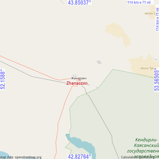
Zhanaozen GPS coordinates[2]
43° 20' 28.176" North, 52° 51' 42.912" East
| Map corner | latitude | longitude |
|---|---|---|
| Upper-left | 43.85037°, | 52.1588° |
| Center: | 43.34116°, | 52.86192° |
| Lower-right: | 42.82764°, | 53.56505° |
| Map W x H: | 113.7×113.7 km | = 70.6×70.6mi |
| max Lat: | 54.90596° ⇑87% North |
| Zhanaozen: | 43.34116° |
| min Lat: | ⇓13% South 40.66338° |
| min Long | Zhanaozen | max Long |
| 46.83361° | 52.86192° | 84.87144° |
| W 10.4%⇐ | ⇒89.6% E |
Elevation
Elevation of Zhanaozen is 204 m = 669 ft, and this is 152.5 m = 500 ft below average elevation for this country.
| Max E: |
1847 m = 6060 ft | 65.2% |
| Avg. | 356.5 m = 1170 ft | |
| Zhanaozen | 204 m = 669 ft | |
Min E: |
-26 m = -85 ft | 34.8% |
See also: Zhanaozen elevation on elevation.city.
Geographical zone
Zhanaozen is located in North temperate zone (between Tropic of Cancer and the Arctic Circle). Distance of this Northern Tropic circle is 2213.2 km =1375.2 mi to South.| Distance of | km | miles | from Zhanaozen |
|---|---|---|---|
| North Pole | 5188 | 3223.7 | to North |
| Arctic Circle | 2582.1 | 1604.4 | to North |
| Tropic Cancer | 2213.2 | 1375.2 | to South |
| Equator | 4819.1 | 2994.4 | to South |


Nearby cities:
15 places around Zhanaozen: (largest is in red/bold)
• Aktau
141 km =87.6 mi,  284°
284°
• Balykshi
421.5 km =261.9 mi,  349°
349°
• Baūtīno
248.5 km =154.4 mi,  302°
302°
• Beyneu
287.8 km =178.8 mi,  40°
40°
• Biikzhal
410.7 km =255.2 mi,  20°
20°
• Fort-Shevchenko
245.1 km =152.3 mi, 301°
• Munayshy
63.1 km =39.2 mi,  285°
285°
• Qaraton
347.5 km =215.9 mi,  8°
8°
• Qulsary
411.7 km =255.8 mi, 12°
• Sayötesh
122.2 km =75.9 mi,  26°
26°
• Shetpe
109.6 km =68.1 mi,  326°
326°
• Taūshyq
165 km =102.5 mi,  312°
312°
• Yeraliyev
97.3 km =60.5 mi,  259°
259°
• Zhetibay
69.2 km =43 mi, 293°
• Ömirzaq
133.8 km =83.1 mi, 282°
Sources, notices
• [Note1] Compared only with cities in Kazakhstan existing in our database
• [Src1] Map data: © OpenStreetMap contributors (CC-BY-SA)
• [Src2] Other city data from geonames.org with taken over terms of usage.
• [Src3] Geographical zone / Annual Mean Temperature by Robert A. Rohde @ Wikipedia
