Kurchum geodata
Kurchum (East Kazakhstan) is a populated place; located in Kazakhstan in Asia/Almaty (GMT+5) time zone. With population of 8,800 people, there are 136 cities with bigger population in this country. Compared to other cities in Kazakhstan, 53.3% of cities are located further ↑North; 97.8% of cities are located further ←West and 65.6% of cities have lower elevation than Kurchum. Note1


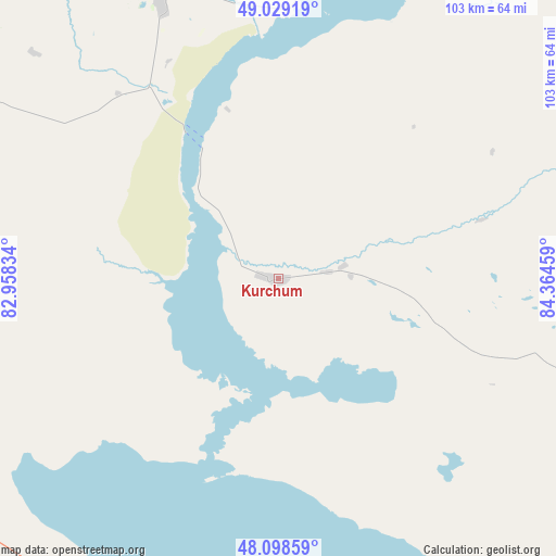
Kurchum GPS coordinates[2]
48° 33' 57.708" North, 83° 39' 41.256" East
| Map corner | latitude | longitude |
|---|---|---|
| Upper-left | 49.02919°, | 82.95834° |
| Center: | 48.56603°, | 83.66146° |
| Lower-right: | 48.09859°, | 84.36459° |
| Map W x H: | 103.5×103.5 km | = 64.3×64.3mi |
| max Lat: | 54.90596° ⇑53.3% North |
| Kurchum: | 48.56603° |
| min Lat: | ⇓46.7% South 40.66338° |
| min Long | Kurchum | max Long |
| 46.83361° | 83.66146° | 84.87144° |
| W 97.8%⇐ | ⇒2.2% E |
Elevation
Elevation of Kurchum is 427 m = 1401 ft, and this is 70.5 m = 231 ft above average elevation for this country.
| Max E: |
1847 m = 6060 ft | 34.4% |
| Kurchum | 427 m 1401 ft | |
| Avg. | 356.5 m = 1170 ft | |
Min E: |
-26 m = -85 ft | 65.6% |
See also: Kazakhstan elevation on elevation.city.
Geographical zone
Kurchum is located in North temperate zone (between Tropic of Cancer and the Arctic Circle). Distance of this North polar circle is 2001.1 km =1243.4 mi to North.| Distance of | km | miles | from Kurchum |
|---|---|---|---|
| North Pole | 4607 | 2862.7 | to North |
| Arctic Circle | 2001.1 | 1243.4 | to North |
| Tropic Cancer | 2794.1 | 1736.2 | to South |
| Equator | 5400 | 3355.4 | to South |


Nearby cities:
15 places around Kurchum: (largest is in red/bold)
• Aksuat
17 km =10.6 mi,  9°
9°
• Asūbulaq
118.5 km =73.6 mi,  338°
338°
• Belogorskīy
108 km =67.1 mi, 339°
• Georgīevka
174.3 km =108.3 mi,  299°
299°
• Kokpekty
94.9 km =59 mi,  282°
282°
• Maleyevsk
146.2 km =90.8 mi,  18°
18°
• Ognevka
132.8 km =82.5 mi, 339°
• Pervorosiyskiy
128.6 km =79.9 mi, 6°
• Priisk Boko
157.5 km =97.9 mi,  290°
290°
• Tūghyl
101.9 km =63.3 mi,  156°
156°
• Ust-Kamenogorsk
174 km =108.1 mi,  333°
333°
• Zaysan
151.8 km =94.3 mi,  143°
143°
• Zhalghyztobe
192.6 km =119.7 mi, 291°
• Zhanga Buqtyrma
118.7 km =73.8 mi,  355°
355°
• Zyryanovsk
136.5 km =84.8 mi, 19°
Sources, notices
• [Note1] Compared only with cities in Kazakhstan existing in our database
• [Src1] Map data: © OpenStreetMap contributors (CC-BY-SA)
• [Src2] Other city data from geonames.org with taken over terms of usage.
• [Src3] Geographical zone / Annual Mean Temperature by Robert A. Rohde @ Wikipedia
