Aksuat geodata
Aksuat is a populated place; located in Kazakhstan in Asia/Almaty (GMT+5) time zone. With population of 6,696 people, there are 161 cities with bigger population in this country. Compared to other cities in Kazakhstan, 51.1% of cities are located further ↑North; 98.1% of cities are located further ←West and 78.1% of cities have lower elevation than Aksuat. Note1


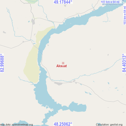
Aksuat GPS coordinates[2]
48° 43' 0.012" North, 83° 42' 0" East
| Map corner | latitude | longitude |
|---|---|---|
| Upper-left | 49.17844°, | 82.99688° |
| Center: | 48.71667°, | 83.7° |
| Lower-right: | 48.25062°, | 84.40313° |
| Map W x H: | 103.2×103.2 km | = 64.1×64.1mi |
| max Lat: | 54.90596° ⇑51.1% North |
| Aksuat: | 48.71667° |
| min Lat: | ⇓48.9% South 40.66338° |
| min Long | Aksuat | max Long |
| 46.83361° | 83.7° | 84.87144° |
| W 98.1%⇐ | ⇒1.9% E |
Elevation
Elevation of Aksuat is 534 m = 1752 ft, and this is 177.5 m = 582 ft above average elevation for this country.
| Max E: |
1847 m = 6060 ft | 21.9% |
| Aksuat | 534 m 1752 ft | |
| Avg. | 356.5 m = 1170 ft | |
Min E: |
-26 m = -85 ft | 78.1% |
See also: Kazakhstan elevation on elevation.city.
Geographical zone
Aksuat is located in North temperate zone (between Tropic of Cancer and the Arctic Circle). Distance of this North polar circle is 1984.4 km =1233 mi to North.| Distance of | km | miles | from Aksuat |
|---|---|---|---|
| North Pole | 4590.3 | 2852.3 | to North |
| Arctic Circle | 1984.4 | 1233 | to North |
| Tropic Cancer | 2810.9 | 1746.6 | to South |
| Equator | 5416.8 | 3365.8 | to South |


Nearby cities:
15 places around Aksuat: (largest is in red/bold)
• Asūbulaq
104.3 km =64.8 mi,  333°
333°
• Belogorskīy
93.6 km =58.2 mi, 334°
• Belousovka
178.9 km =111.2 mi, 331°
• Georgīevka
169.2 km =105.1 mi,  293°
293°
• Kokpekty
95.4 km =59.3 mi,  272°
272°
• Kurchum
17 km =10.6 mi,  189°
189°
• Maleyevsk
129.4 km =80.4 mi,  19°
19°
• Ognevka
118.4 km =73.6 mi,  335°
335°
• Pervorosiyskiy
111.7 km =69.4 mi,  5°
5°
• Priisk Boko
155 km =96.3 mi,  284°
284°
• Tūghyl
116.4 km =72.3 mi,  161°
161°
• Ust-Kamenogorsk
160.5 km =99.7 mi, 330°
• Zaysan
164 km =101.9 mi,  147°
147°
• Zhanga Buqtyrma
102.3 km =63.6 mi,  352°
352°
• Zyryanovsk
119.8 km =74.4 mi, 20°
Sources, notices
• [Note1] Compared only with cities in Kazakhstan existing in our database
• [Src1] Map data: © OpenStreetMap contributors (CC-BY-SA)
• [Src2] Other city data from geonames.org with taken over terms of usage.
• [Src3] Geographical zone / Annual Mean Temperature by Robert A. Rohde @ Wikipedia
