Kandy geodata
Kandy (Central) is a seat of a first-order administrative division; located in Sri Lanka in Asia/Colombo (GMT+5.5) time zone. With population of 111,701 people, there are 7 cities with bigger population in this country. Compared to other cities in Sri Lanka, 71.1% of cities are located further ↓South; 73.7% of cities are located further ←West and 90.8% of cities have lower elevation than Kandy. Note1


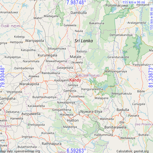
Kandy GPS coordinates[2]
7° 17' 26.16" North, 80° 38' 0.96" East
| Map corner | latitude | longitude |
|---|---|---|
| Upper-left | 7.98748°, | 79.93048° |
| Center: | 7.2906°, | 80.6336° |
| Lower-right: | 6.59263°, | 81.33673° |
| Map W x H: | 155.1×155.1 km | = 96.4×96.4mi |
| max Lat: | 9.81667° ⇑28.9% North |
| Kandy: | 7.2906° |
| min Lat: | ⇓71.1% South 5.92825° |
| min Long | Kandy | max Long |
| 79.79528° | 80.6336° | 81.83472° |
| W 73.7%⇐ | ⇒26.3% E |
Elevation
Elevation of Kandy is 514 m = 1686 ft, and this is 356.6 m = 1170 ft above average elevation for this country.
| Max E: |
1868 m = 6129 ft | 9.2% |
| Kandy | 514 m 1686 ft | |
| Avg. | 157.4 m = 516 ft | |
Min E: |
1 m = 3 ft | 90.8% |
See also: Kandy elevation on elevation.city.
Geographical zone
Kandy is located in North Torrid zone (between Equator and Tropic of Cancer). Distance of Equator is 810.6 km =503.7 mi to South.| Distance of | km | miles | from Kandy |
|---|---|---|---|
| North Pole | 9196.4 | 5714.4 | to North |
| Arctic Circle | 6590.5 | 4095.1 | to North |
| Tropic Cancer | 1795.3 | 1115.5 | to North |
| Equator | 810.6 | 503.7 | to South |


Nearby cities:
15 places around Kandy: (largest is in red/bold)
• Badulla
58.1 km =36.1 mi,  126°
126°
• Dambulla
63.3 km =39.3 mi,  1°
1°
• Ella Town
64.8 km =40.3 mi,  135°
135°
• Gampaha
74.2 km =46.1 mi,  252°
252°
• Gampola
15.7 km =9.8 mi,  206°
206°
• Haputale
68.1 km =42.3 mi,  149°
149°
• Hatton
44.6 km =27.7 mi,  185°
185°
• Kadugannawa
12.7 km =7.9 mi, 251°
• Kegalle
32.3 km =20.1 mi,  262°
262°
• Kuliyapitiya
68.4 km =42.5 mi,  286°
286°
• Kurunegala
36.3 km =22.6 mi,  306°
306°
• Matale
20 km =12.4 mi,  356°
356°
• Nuwara Eliya
39.2 km =24.4 mi,  155°
155°
• Ratnapura
71.9 km =44.7 mi,  200°
200°
• Talawakele
39.4 km =24.5 mi,  176°
176°
Sources, notices
• [Note1] Compared only with cities in Sri Lanka existing in our database
• [Src1] Map data: © OpenStreetMap contributors (CC-BY-SA)
• [Src2] Other city data from geonames.org with taken over terms of usage.
• [Src3] Geographical zone / Annual Mean Temperature by Robert A. Rohde @ Wikipedia
