Eravur Town geodata
Eravur Town (Eastern Province) is a populated place; located in Sri Lanka in Asia/Colombo (GMT+5.5) time zone. With population of 22,982 people, there are 45 cities with bigger population in this country. Compared to other cities in Sri Lanka, 81.6% of cities are located further ↓South; 96.1% of cities are located further ←West and 73.7% of cities have higher elevation than Eravur Town. Note1
Administrative division(s):
- Level 1: Eastern Province
- Level 2: Batticaloa District
- Level 3: Eravur Town Division


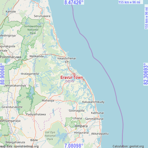
Eravur Town GPS coordinates[2]
7° 46' 41.52" North, 81° 36' 13.68" East
| Map corner | latitude | longitude |
|---|---|---|
| Upper-left | 8.47426°, | 80.90068° |
| Center: | 7.7782°, | 81.6038° |
| Lower-right: | 7.08098°, | 82.30693° |
| Map W x H: | 154.9×154.9 km | = 96.3×96.3mi |
| max Lat: | 9.81667° ⇑18.4% North |
| Eravur Town: | 7.7782° |
| min Lat: | ⇓81.6% South 5.92825° |
| min Long | Eravur Town | max Long |
| 79.79528° | 81.6038° | 81.83472° |
| W 96.1%⇐ | ⇒3.9% E |
Elevation
Elevation of Eravur Town is 10 m = 33 ft, and this is 147.4 m = 484 ft below average elevation for this country.
| Max E: |
1868 m = 6129 ft | 73.7% |
| Avg. | 157.4 m = 516 ft | |
| Eravur Town | 10 m = 33 ft | |
Min E: |
1 m = 3 ft | 26.3% |
See also: Sri Lanka elevation on elevation.city.
Geographical zone
Eravur Town is located in North Torrid zone (between Equator and Tropic of Cancer). Distance of Equator is 864.9 km =537.4 mi to South.| Distance of | km | miles | from Eravur Town |
|---|---|---|---|
| North Pole | 9142.2 | 5680.7 | to North |
| Arctic Circle | 6536.3 | 4061.5 | to North |
| Tropic Cancer | 1741.1 | 1081.9 | to North |
| Equator | 864.9 | 537.4 | to South |


Nearby cities:
15 places around Eravur Town: (largest is in red/bold)
• Ampara
54.1 km =33.6 mi,  170°
170°
• Badulla
107.2 km =66.6 mi,  214°
214°
• Batticaloa
12.3 km =7.6 mi,  127°
127°
• Dambulla
105.3 km =65.4 mi,  274°
274°
• Ella Town
117.7 km =73.1 mi, 211°
• Kalmunai
48.3 km =30 mi,  148°
148°
• Kandy
119.9 km =74.5 mi,  243°
243°
• Matale
113.5 km =70.5 mi,  252°
252°
• Monaragala
104.7 km =65.1 mi,  195°
195°
• Nuwara Eliya
127.5 km =79.2 mi,  225°
225°
• Polonnaruwa
68.6 km =42.6 mi,  285°
285°
• Sigiriya
95.9 km =59.6 mi,  281°
281°
• Trincomalee
98 km =60.9 mi,  335°
335°
• Vakarai
43.7 km =27.2 mi,  334°
334°
• Wattegama
109.7 km =68.2 mi,  187°
187°
Sources, notices
• [Note1] Compared only with cities in Sri Lanka existing in our database
• [Src1] Map data: © OpenStreetMap contributors (CC-BY-SA)
• [Src2] Other city data from geonames.org with taken over terms of usage.
• [Src3] Geographical zone / Annual Mean Temperature by Robert A. Rohde @ Wikipedia
