Ampara geodata
Ampara (Eastern Province) is a populated place; located in Sri Lanka in Asia/Colombo (GMT+5.5) time zone. With population of 18,348 people, there are 51 cities with bigger population in this country. Compared to other cities in Sri Lanka, 72.4% of cities are located further ↓South; 97.4% of cities are located further ←West and 67.1% of cities have lower elevation than Ampara. Note1
Administrative division(s):
- Level 1: Eastern Province
- Level 2: Ampara District
- Level 3: Ampara
- Level 4: Jayawardhanapura


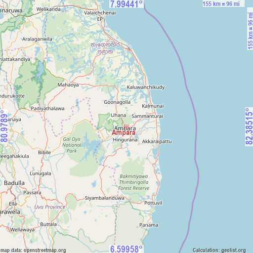
Ampara GPS coordinates[2]
7° 17' 51.144" North, 81° 40' 55.272" East
| Map corner | latitude | longitude |
|---|---|---|
| Upper-left | 7.99441°, | 80.9789° |
| Center: | 7.29754°, | 81.68202° |
| Lower-right: | 6.59958°, | 82.38515° |
| Map W x H: | 155.1×155.1 km | = 96.4×96.4mi |
| max Lat: | 9.81667° ⇑27.6% North |
| Ampara: | 7.29754° |
| min Lat: | ⇓72.4% South 5.92825° |
| min Long | Ampara | max Long |
| 79.79528° | 81.68202° | 81.83472° |
| W 97.4%⇐ | ⇒2.6% E |
Elevation
Elevation of Ampara is 37 m = 121 ft, and this is 120.4 m = 395 ft below average elevation for this country.
| Max E: |
1868 m = 6129 ft | 32.9% |
| Avg. | 157.4 m = 516 ft | |
| Ampara | 37 m = 121 ft | |
Min E: |
1 m = 3 ft | 67.1% |
See also: Sri Lanka elevation on elevation.city.
Geographical zone
Ampara is located in North Torrid zone (between Equator and Tropic of Cancer). Distance of Equator is 811.4 km =504.2 mi to South.| Distance of | km | miles | from Ampara |
|---|---|---|---|
| North Pole | 9195.7 | 5713.9 | to North |
| Arctic Circle | 6589.8 | 4094.7 | to North |
| Tropic Cancer | 1794.5 | 1115.1 | to North |
| Equator | 811.4 | 504.2 | to South |


Nearby cities:
15 places around Ampara: (largest is in red/bold)
• Badulla
77.4 km =48.1 mi,  242°
242°
• Batticaloa
45.9 km =28.5 mi,  1°
1°
• Ella Town
84.4 km =52.4 mi, 236°
• Eravur Town
54.1 km =33.6 mi,  350°
350°
• Haputale
100 km =62.1 mi,  233°
233°
• Kalmunai
20.9 km =13 mi,  53°
53°
• Kandy
115.6 km =71.8 mi,  269°
269°
• Kataragama
105.5 km =65.6 mi,  201°
201°
• Matale
118.5 km =73.6 mi,  279°
279°
• Monaragala
60 km =37.3 mi,  217°
217°
• Nuwara Eliya
105.6 km =65.6 mi,  249°
249°
• Polonnaruwa
103.4 km =64.2 mi,  313°
313°
• Vakarai
96.9 km =60.2 mi,  343°
343°
• Wattegama
59.7 km =37.1 mi, 201°
• Wellawaya
89.3 km =55.5 mi, 225°
Sources, notices
• [Note1] Compared only with cities in Sri Lanka existing in our database
• [Src1] Map data: © OpenStreetMap contributors (CC-BY-SA)
• [Src2] Other city data from geonames.org with taken over terms of usage.
• [Src3] Geographical zone / Annual Mean Temperature by Robert A. Rohde @ Wikipedia
