Batticaloa geodata
Batticaloa (Eastern Province) is a populated place; located in Sri Lanka in Asia/Colombo (GMT+5.5) time zone. With population of 86,742 people, there are 12 cities with bigger population in this country. Compared to other cities in Sri Lanka, 80.3% of cities are located further ↓South; 98.7% of cities are located further ←West and 50% of cities have lower elevation than Batticaloa. Note1
Administrative division(s):
- Level 1: Eastern Province
- Level 2: Batticaloa District
- Level 3: Manmunai North Division


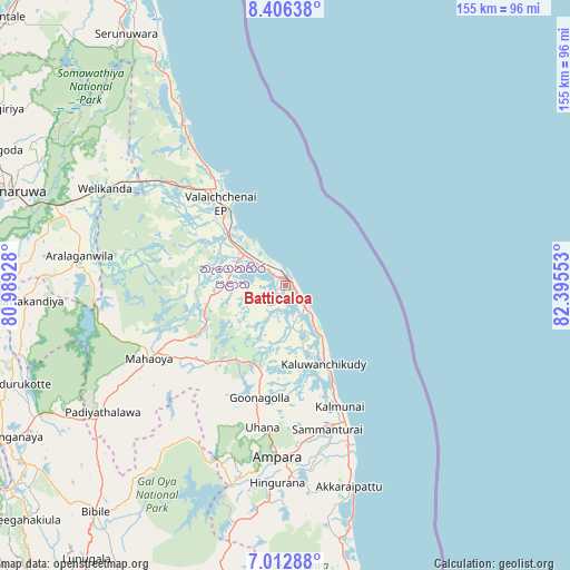
Batticaloa GPS coordinates[2]
7° 42' 36.72" North, 81° 41' 32.64" East
| Map corner | latitude | longitude |
|---|---|---|
| Upper-left | 8.40638°, | 80.98928° |
| Center: | 7.7102°, | 81.6924° |
| Lower-right: | 7.01288°, | 82.39553° |
| Map W x H: | 154.9×154.9 km | = 96.3×96.3mi |
| max Lat: | 9.81667° ⇑19.7% North |
| Batticaloa: | 7.7102° |
| min Lat: | ⇓80.3% South 5.92825° |
| min Long | Batticaloa | max Long |
| 79.79528° | 81.6924° | 81.83472° |
| W 98.7%⇐ | ⇒1.3% E |
Elevation
Elevation of Batticaloa is 17 m = 56 ft, and this is 140.4 m = 461 ft below average elevation for this country.
| Max E: |
1868 m = 6129 ft | 50% |
| Avg. | 157.4 m = 516 ft | |
| Batticaloa | 17 m = 56 ft | |
Min E: |
1 m = 3 ft | 50% |
See also: Batticaloa elevation on elevation.city.
Geographical zone
Batticaloa is located in North Torrid zone (between Equator and Tropic of Cancer). Distance of Equator is 857.3 km =532.7 mi to South.| Distance of | km | miles | from Batticaloa |
|---|---|---|---|
| North Pole | 9149.8 | 5685.4 | to North |
| Arctic Circle | 6543.9 | 4066.2 | to North |
| Tropic Cancer | 1748.6 | 1086.5 | to North |
| Equator | 857.3 | 532.7 | to South |


Nearby cities:
15 places around Batticaloa: (largest is in red/bold)
• Ampara
45.9 km =28.5 mi,  181°
181°
• Badulla
107.2 km =66.6 mi,  220°
220°
• Dambulla
115.9 km =72 mi,  278°
278°
• Ella Town
117 km =72.7 mi, 217°
• Eravur Town
12.3 km =7.6 mi,  307°
307°
• Kalmunai
37 km =23 mi,  154°
154°
• Kandy
125.7 km =78.1 mi,  248°
248°
• Matale
121 km =75.2 mi,  257°
257°
• Monaragala
100.7 km =62.6 mi,  202°
202°
• Polonnaruwa
80.1 km =49.8 mi,  288°
288°
• Sigiriya
107.1 km =66.5 mi, 284°
• Trincomalee
109.1 km =67.8 mi,  332°
332°
• Vakarai
55 km =34.2 mi, 328°
• Wattegama
104 km =64.6 mi,  192°
192°
• Wellawaya
126.3 km =78.5 mi,  211°
211°
Sources, notices
• [Note1] Compared only with cities in Sri Lanka existing in our database
• [Src1] Map data: © OpenStreetMap contributors (CC-BY-SA)
• [Src2] Other city data from geonames.org with taken over terms of usage.
• [Src3] Geographical zone / Annual Mean Temperature by Robert A. Rohde @ Wikipedia
