Kataragama geodata
Kataragama (Uva) is a populated place; located in Sri Lanka in Asia/Colombo (GMT+5.5) time zone. With population of 20,935 people, there are 49 cities with bigger population in this country. Compared to other cities in Sri Lanka, 85.5% of cities are located further ↑North; 90.8% of cities are located further ←West and 69.7% of cities have lower elevation than Kataragama. Note1
Administrative division(s):
- Level 1: Uva
- Level 2: Moneragala District
- Level 3: Katharagama
- Level 4: Detagamuwa


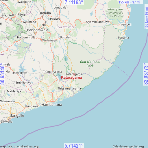
Kataragama GPS coordinates[2]
6° 24' 48.24" North, 81° 20' 4.56" East
| Map corner | latitude | longitude |
|---|---|---|
| Upper-left | 7.11163°, | 80.63148° |
| Center: | 6.4134°, | 81.3346° |
| Lower-right: | 5.71421°, | 82.03773° |
| Map W x H: | 155.4×155.4 km | = 96.6×96.6mi |
| max Lat: | 9.81667° ⇑85.5% North |
| Kataragama: | 6.4134° |
| min Lat: | ⇓14.5% South 5.92825° |
| min Long | Kataragama | max Long |
| 79.79528° | 81.3346° | 81.83472° |
| W 90.8%⇐ | ⇒9.2% E |
Elevation
Elevation of Kataragama is 48 m = 157 ft, and this is 109.4 m = 359 ft below average elevation for this country.
| Max E: |
1868 m = 6129 ft | 30.3% |
| Avg. | 157.4 m = 516 ft | |
| Kataragama | 48 m = 157 ft | |
Min E: |
1 m = 3 ft | 69.7% |
See also: Sri Lanka elevation on elevation.city.
Geographical zone
Kataragama is located in North Torrid zone (between Equator and Tropic of Cancer). Distance of Equator is 713.1 km =443.1 mi to South.| Distance of | km | miles | from Kataragama |
|---|---|---|---|
| North Pole | 9294 | 5775 | to North |
| Arctic Circle | 6688.1 | 4155.8 | to North |
| Tropic Cancer | 1892.8 | 1176.1 | to North |
| Equator | 713.1 | 443.1 | to South |


Nearby cities:
15 places around Kataragama: (largest is in red/bold)
• Ampara
105.5 km =65.6 mi,  21°
21°
• Badulla
70 km =43.5 mi,  334°
334°
• Devinuwara
98.5 km =61.2 mi,  236°
236°
• Ella Town
60.5 km =37.6 mi, 328°
• Haputale
57.7 km =35.9 mi,  312°
312°
• Hatton
97.4 km =60.5 mi,  303°
303°
• Matara
102.4 km =63.6 mi, 239°
• Mirissa city
109.9 km =68.3 mi, 241°
• Monaragala
50.9 km =31.6 mi,  1°
1°
• Nuwara Eliya
86.9 km =54 mi,  315°
315°
• Ratnapura
107.2 km =66.6 mi,  286°
286°
• Talawakele
94.7 km =58.8 mi, 307°
• Tangalle
73.5 km =45.7 mi,  233°
233°
• Wattegama
45.8 km =28.5 mi, 20°
• Wellawaya
44.2 km =27.5 mi, 324°
Sources, notices
• [Note1] Compared only with cities in Sri Lanka existing in our database
• [Src1] Map data: © OpenStreetMap contributors (CC-BY-SA)
• [Src2] Other city data from geonames.org with taken over terms of usage.
• [Src3] Geographical zone / Annual Mean Temperature by Robert A. Rohde @ Wikipedia
