Cestos City geodata
Cestos City (River Cess) is a seat of a first-order administrative division; located in Liberia in Africa/Monrovia (GMT+0) time zone. With population of 2,578 people, there are 17 cities with bigger population in this country. Compared to other cities in Liberia, 77.8% of cities are located further ↑North; 55.6% of cities are located further →East and 100% of cities have higher elevation than Cestos City. Note1


Cestos City GPS coordinates[2]
5° 27' 24.588" North, 9° 34' 54.012" West
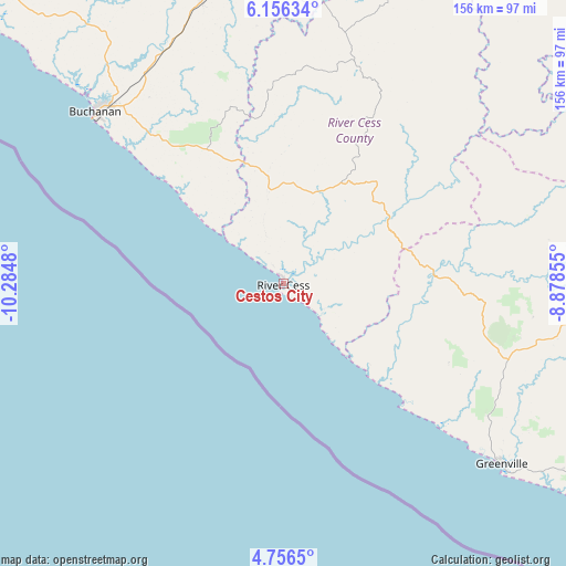
| Map corner | latitude | longitude |
|---|---|---|
| Upper-left | 6.15634°, | -10.2848° |
| Center: | 5.45683°, | -9.58167° |
| Lower-right: | 4.7565°, | -8.87855° |
| Map W x H: | 155.6×155.7 km | = 96.7×96.7mi |
| max Lat: | 8.42194° ⇑77.8% North |
| Cestos City: | 5.45683° |
| min Lat: | ⇓22.2% South 4.3782° |
| min Long | Cestos City | max Long |
| -11.3671° | -9.58167° | -7.71081° |
| W 44.4%⇐ | ⇒55.6% E |
Elevation
Elevation of Cestos City is 5 m = 16 ft, and this is 174.1 m = 571 ft below average elevation for this country.
| Max E: |
550 m = 1804 ft | 100% |
| Avg. | 179.1 m = 588 ft | |
| Cestos City | 5 m = 16 ft | |
Min E: |
5 m = 16 ft | 0% |
See also: Liberia elevation on elevation.city.
Geographical zone
Cestos City is located in North Torrid zone (between Equator and Tropic of Cancer). Distance of Equator is 606.7 km =377 mi to South.| Distance of | km | miles | from Cestos City |
|---|---|---|---|
| North Pole | 9400.3 | 5841.1 | to North |
| Arctic Circle | 6794.4 | 4221.8 | to North |
| Tropic Cancer | 1999.2 | 1242.2 | to North |
| Equator | 606.7 | 377 | to South |


Nearby cities:
15 places around Cestos City: (largest is in red/bold)
• Barclayville
172.9 km =107.4 mi,  120°
120°
• Bensonville
158.5 km =98.5 mi,  313°
313°
• Bopolu
205.1 km =127.4 mi,  330°
330°
• Buchanan
69.7 km =43.3 mi, 312°
• Buutuo
204.9 km =127.3 mi,  41°
41°
• Fish Town
191 km =118.7 mi,  98°
98°
• Ganta
235.8 km =146.5 mi,  29°
29°
• Gbarnga
171.5 km =106.6 mi,  4°
4°
• Greenville
77.9 km =48.4 mi,  129°
129°
• Harper
239.5 km =148.8 mi, 120°
• Kakata
146.8 km =91.2 mi,  324°
324°
• Monrovia
163.9 km =101.8 mi,  304°
304°
• Sanniquellie
232.6 km =144.5 mi,  24°
24°
• Tubmanburg
208.5 km =129.6 mi, 318°
• Zwedru
173.8 km =108 mi,  66°
66°
Sources, notices
• [Note1] Compared only with cities in Liberia existing in our database
• [Src1] Map data: © OpenStreetMap contributors (CC-BY-SA)
• [Src2] Other city data from geonames.org with taken over terms of usage.
• [Src3] Geographical zone / Annual Mean Temperature by Robert A. Rohde @ Wikipedia
