Gbarnga geodata
Gbarnga (Bong) is a seat of a first-order administrative division; located in Liberia in Africa/Monrovia (GMT+0) time zone. With population of 45,835 people, there is 1 city with bigger population in this country. Compared to other cities in Liberia, 72.2% of cities are located further ↓South; 50% of cities are located further ←West and 77.8% of cities have lower elevation than Gbarnga. Note1


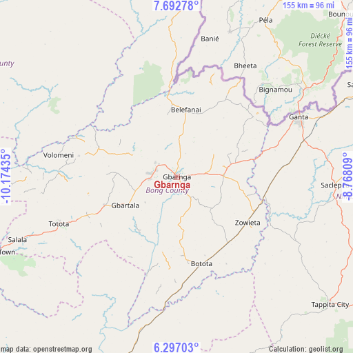
Gbarnga GPS coordinates[2]
6° 59' 43.548" North, 9° 28' 16.392" West
| Map corner | latitude | longitude |
|---|---|---|
| Upper-left | 7.69278°, | -10.17435° |
| Center: | 6.99543°, | -9.47122° |
| Lower-right: | 6.29703°, | -8.76809° |
| Map W x H: | 155.2×155.2 km | = 96.4×96.4mi |
| max Lat: | 8.42194° ⇑27.8% North |
| Gbarnga: | 6.99543° |
| min Lat: | ⇓72.2% South 4.3782° |
| min Long | Gbarnga | max Long |
| -11.3671° | -9.47122° | -7.71081° |
| W 50%⇐ | ⇒50% E |
Elevation
Elevation of Gbarnga is 253 m = 830 ft, and this is 73.9 m = 242 ft above average elevation for this country.
| Max E: |
550 m = 1804 ft | 22.2% |
| Gbarnga | 253 m 830 ft | |
| Avg. | 179.1 m = 588 ft | |
Min E: |
5 m = 16 ft | 77.8% |
See also: Gbarnga elevation on elevation.city.
Geographical zone
Gbarnga is located in North Torrid zone (between Equator and Tropic of Cancer). Distance of Equator is 777.8 km =483.3 mi to South.| Distance of | km | miles | from Gbarnga |
|---|---|---|---|
| North Pole | 9229.2 | 5734.8 | to North |
| Arctic Circle | 6623.4 | 4115.6 | to North |
| Tropic Cancer | 1828.1 | 1135.9 | to North |
| Equator | 777.8 | 483.3 | to South |


Nearby cities:
15 places around Gbarnga: (largest is in red/bold)
• Bensonville
140 km =87 mi,  244°
244°
• Bopolu
112.4 km =69.8 mi,  274°
274°
• Buchanan
139.8 km =86.9 mi,  207°
207°
• Buutuo
125.9 km =78.2 mi,  98°
98°
• Cestos City
171.5 km =106.6 mi,  184°
184°
• Ganta
109.2 km =67.9 mi,  71°
71°
• Greenville
225.7 km =140.2 mi,  167°
167°
• Kakata
110.3 km =68.5 mi, 242°
• Monrovia
165.5 km =102.8 mi, 242°
• New Yekepa
121.7 km =75.6 mi,  57°
57°
• Robertsport
211 km =131.1 mi,  262°
262°
• Sanniquellie
93 km =57.8 mi, 64°
• Tubmanburg
149.6 km =93 mi, 264°
• Voinjama
161.5 km =100.4 mi,  349°
349°
• Zwedru
180 km =111.8 mi,  124°
124°
Sources, notices
• [Note1] Compared only with cities in Liberia existing in our database
• [Src1] Map data: © OpenStreetMap contributors (CC-BY-SA)
• [Src2] Other city data from geonames.org with taken over terms of usage.
• [Src3] Geographical zone / Annual Mean Temperature by Robert A. Rohde @ Wikipedia
