Kakata geodata
Kakata (Margibi) is a seat of a first-order administrative division; located in Liberia in Africa/Monrovia (GMT+0) time zone. With population of 33,945 people, there are 2 cities with bigger population in this country. Compared to other cities in Liberia, 50% of cities are located further ↓South; 72.2% of cities are located further →East and 50% of cities have lower elevation than Kakata. Note1


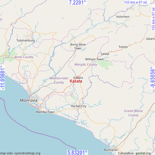
Kakata GPS coordinates[2]
6° 31' 51.744" North, 10° 21' 13.248" West
| Map corner | latitude | longitude |
|---|---|---|
| Upper-left | 7.2291°, | -11.05681° |
| Center: | 6.53104°, | -10.35368° |
| Lower-right: | 5.83201°, | -9.65056° |
| Map W x H: | 155.3×155.3 km | = 96.5×96.5mi |
| max Lat: | 8.42194° ⇑50% North |
| Kakata: | 6.53104° |
| min Lat: | ⇓50% South 4.3782° |
| min Long | Kakata | max Long |
| -11.3671° | -10.35368° | -7.71081° |
| W 27.8%⇐ | ⇒72.2% E |
Elevation
Elevation of Kakata is 97 m = 318 ft, and this is 82.1 m = 269 ft below average elevation for this country.
| Max E: |
550 m = 1804 ft | 50% |
| Avg. | 179.1 m = 588 ft | |
| Kakata | 97 m = 318 ft | |
Min E: |
5 m = 16 ft | 50% |
See also: Liberia elevation on elevation.city.
Geographical zone
Kakata is located in North Torrid zone (between Equator and Tropic of Cancer). Distance of Equator is 726.2 km =451.2 mi to South.| Distance of | km | miles | from Kakata |
|---|---|---|---|
| North Pole | 9280.9 | 5766.9 | to North |
| Arctic Circle | 6675 | 4147.7 | to North |
| Tropic Cancer | 1879.7 | 1168 | to North |
| Equator | 726.2 | 451.2 | to South |


Nearby cities:
15 places around Kakata: (largest is in red/bold)
• Bensonville
30.1 km =18.7 mi,  251°
251°
• Bopolu
61.4 km =38.2 mi,  346°
346°
• Buchanan
80.1 km =49.8 mi,  155°
155°
• Buutuo
224.5 km =139.5 mi,  81°
81°
• Cestos City
146.8 km =91.2 mi,  144°
144°
• Ganta
218.7 km =135.9 mi,  66°
66°
• Gbarnga
110.3 km =68.5 mi,  62°
62°
• Greenville
223 km =138.6 mi, 139°
• Monrovia
55.3 km =34.4 mi,  242°
242°
• New Yekepa
231.8 km =144 mi, 59°
• Robertsport
114.6 km =71.2 mi,  282°
282°
• Sanniquellie
203.3 km =126.3 mi, 62°
• Tubmanburg
64 km =39.8 mi,  306°
306°
• Voinjama
220.6 km =137.1 mi,  17°
17°
• Zwedru
250.5 km =155.7 mi,  101°
101°
Sources, notices
• [Note1] Compared only with cities in Liberia existing in our database
• [Src1] Map data: © OpenStreetMap contributors (CC-BY-SA)
• [Src2] Other city data from geonames.org with taken over terms of usage.
• [Src3] Geographical zone / Annual Mean Temperature by Robert A. Rohde @ Wikipedia
