Greenville geodata
Greenville (Sinoe) is a seat of a first-order administrative division; located in Liberia in Africa/Monrovia (GMT+0) time zone. With population of 16,434 people, there are 9 cities with bigger population in this country. Compared to other cities in Liberia, 88.9% of cities are located further ↑North; 55.6% of cities are located further ←West and 94.4% of cities have higher elevation than Greenville. Note1


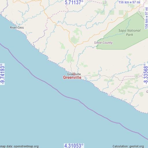
Greenville GPS coordinates[2]
5° 0' 40.788" North, 9° 2' 19.68" West
| Map corner | latitude | longitude |
|---|---|---|
| Upper-left | 5.71137°, | -9.74193° |
| Center: | 5.01133°, | -9.0388° |
| Lower-right: | 4.31053°, | -8.33568° |
| Map W x H: | 155.8×155.8 km | = 96.8×96.8mi |
| max Lat: | 8.42194° ⇑88.9% North |
| Greenville: | 5.01133° |
| min Lat: | ⇓11.1% South 4.3782° |
| min Long | Greenville | max Long |
| -11.3671° | -9.0388° | -7.71081° |
| W 55.6%⇐ | ⇒44.4% E |
Elevation
Elevation of Greenville is 10 m = 33 ft, and this is 169.1 m = 555 ft below average elevation for this country.
| Max E: |
550 m = 1804 ft | 94.4% |
| Avg. | 179.1 m = 588 ft | |
| Greenville | 10 m = 33 ft | |
Min E: |
5 m = 16 ft | 5.6% |
See also: Liberia elevation on elevation.city.
Geographical zone
Greenville is located in North Torrid zone (between Equator and Tropic of Cancer). Distance of Equator is 557.2 km =346.2 mi to South.| Distance of | km | miles | from Greenville |
|---|---|---|---|
| North Pole | 9449.9 | 5871.9 | to North |
| Arctic Circle | 6844 | 4252.7 | to North |
| Tropic Cancer | 2048.7 | 1273 | to North |
| Equator | 557.2 | 346.2 | to South |


Nearby cities:
15 places around Greenville: (largest is in red/bold)
• Barclayville
96.8 km =60.1 mi,  112°
112°
• Bensonville
236.2 km =146.8 mi,  312°
312°
• Bopolu
279.1 km =173.4 mi,  324°
324°
• Buchanan
147.6 km =91.7 mi, 310°
• Buutuo
216.1 km =134.3 mi,  20°
20°
• Cestos City
77.9 km =48.4 mi, 309°
• Fish Town
130.5 km =81.1 mi,  80°
80°
• Ganta
260.8 km =162.1 mi,  12°
12°
• Gbarnga
225.7 km =140.2 mi,  347°
347°
• Harper
163.1 km =101.3 mi,  115°
115°
• Kakata
223 km =138.6 mi, 319°
• Monrovia
241.6 km =150.1 mi, 306°
• Sanniquellie
263.9 km =164 mi, 7°
• Tubmanburg
285.6 km =177.5 mi, 316°
• Zwedru
154.3 km =95.9 mi,  40°
40°
Sources, notices
• [Note1] Compared only with cities in Liberia existing in our database
• [Src1] Map data: © OpenStreetMap contributors (CC-BY-SA)
• [Src2] Other city data from geonames.org with taken over terms of usage.
• [Src3] Geographical zone / Annual Mean Temperature by Robert A. Rohde @ Wikipedia
