Buchanan geodata
Buchanan (Grand Bassa) is a seat of a first-order administrative division; located in Liberia in Africa/Monrovia (GMT+0) time zone. With population of 25,731 people, there are 6 cities with bigger population in this country. Compared to other cities in Liberia, 72.2% of cities are located further ↑North; 66.7% of cities are located further →East and 55.6% of cities have higher elevation than Buchanan. Note1


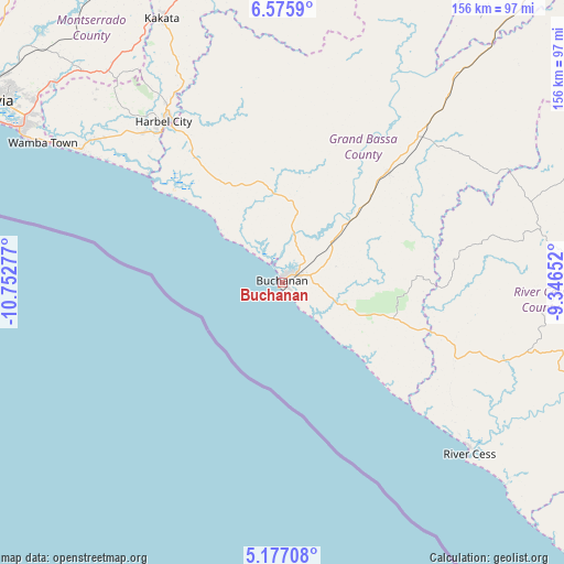
Buchanan GPS coordinates[2]
5° 52' 36.948" North, 10° 2' 58.704" West
| Map corner | latitude | longitude |
|---|---|---|
| Upper-left | 6.5759°, | -10.75277° |
| Center: | 5.87693°, | -10.04964° |
| Lower-right: | 5.17708°, | -9.34652° |
| Map W x H: | 155.5×155.5 km | = 96.6×96.6mi |
| max Lat: | 8.42194° ⇑72.2% North |
| Buchanan: | 5.87693° |
| min Lat: | ⇓27.8% South 4.3782° |
| min Long | Buchanan | max Long |
| -11.3671° | -10.04964° | -7.71081° |
| W 33.3%⇐ | ⇒66.7% E |
Elevation
Elevation of Buchanan is 78 m = 256 ft, and this is 101.1 m = 332 ft below average elevation for this country.
| Max E: |
550 m = 1804 ft | 55.6% |
| Avg. | 179.1 m = 588 ft | |
| Buchanan | 78 m = 256 ft | |
Min E: |
5 m = 16 ft | 44.4% |
See also: Liberia elevation on elevation.city.
Geographical zone
Buchanan is located in North Torrid zone (between Equator and Tropic of Cancer). Distance of Equator is 653.5 km =406.1 mi to South.| Distance of | km | miles | from Buchanan |
|---|---|---|---|
| North Pole | 9353.6 | 5812.1 | to North |
| Arctic Circle | 6747.7 | 4192.8 | to North |
| Tropic Cancer | 1952.5 | 1213.2 | to North |
| Equator | 653.5 | 406.1 | to South |


Nearby cities:
15 places around Buchanan: (largest is in red/bold)
• Barclayville
241.5 km =150.1 mi,  123°
123°
• Bensonville
88.9 km =55.2 mi,  315°
315°
• Bopolu
140.9 km =87.6 mi,  339°
339°
• Buutuo
216.2 km =134.3 mi,  60°
60°
• Cestos City
69.7 km =43.3 mi,  132°
132°
• Fish Town
252.2 km =156.7 mi,  107°
107°
• Ganta
230.8 km =143.4 mi,  46°
46°
• Gbarnga
139.8 km =86.9 mi,  27°
27°
• Greenville
147.6 km =91.7 mi, 130°
• Kakata
80.1 km =49.8 mi, 335°
• Monrovia
95.1 km =59.1 mi,  299°
299°
• Robertsport
175.2 km =108.9 mi, 303°
• Sanniquellie
221.5 km =137.6 mi,  41°
41°
• Tubmanburg
139.6 km =86.7 mi, 322°
• Zwedru
212.7 km =132.2 mi,  84°
84°
Sources, notices
• [Note1] Compared only with cities in Liberia existing in our database
• [Src1] Map data: © OpenStreetMap contributors (CC-BY-SA)
• [Src2] Other city data from geonames.org with taken over terms of usage.
• [Src3] Geographical zone / Annual Mean Temperature by Robert A. Rohde @ Wikipedia
