Harper geodata
Harper (Maryland) is a seat of a first-order administrative division; located in Liberia in Africa/Monrovia (GMT+0) time zone. With population of 32,661 people, there are 4 cities with bigger population in this country. Compared to other cities in Liberia, 100% of cities are located further ↑North; 100% of cities are located further ←West and 88.9% of cities have higher elevation than Harper. Note1


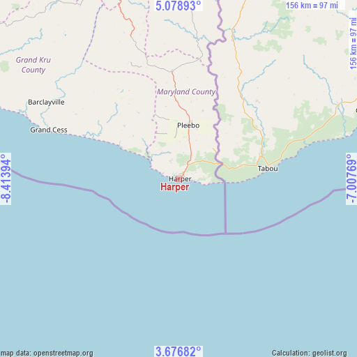
Harper GPS coordinates[2]
4° 22' 41.52" North, 7° 42' 38.916" West
| Map corner | latitude | longitude |
|---|---|---|
| Upper-left | 5.07893°, | -8.41394° |
| Center: | 4.3782°, | -7.71081° |
| Lower-right: | 3.67682°, | -7.00769° |
| Map W x H: | 155.9×155.9 km | = 96.9×96.9mi |
| max Lat: | 8.42194° ⇑100% North |
| Harper: | 4.3782° |
| min Lat: | ⇓0% South 4.3782° |
| min Long | Harper | max Long |
| -11.3671° | -7.71081° | -7.71081° |
| W 100%⇐ | ⇒0% E |
Elevation
Elevation of Harper is 14 m = 46 ft, and this is 165.1 m = 542 ft below average elevation for this country.
| Max E: |
550 m = 1804 ft | 88.9% |
| Avg. | 179.1 m = 588 ft | |
| Harper | 14 m = 46 ft | |
Min E: |
5 m = 16 ft | 11.1% |
See also: Liberia elevation on elevation.city.
Geographical zone
Harper is located in North Torrid zone (between Equator and Tropic of Cancer). Distance of Equator is 486.8 km =302.5 mi to South.| Distance of | km | miles | from Harper |
|---|---|---|---|
| North Pole | 9520.3 | 5915.6 | to North |
| Arctic Circle | 6914.4 | 4296.4 | to North |
| Tropic Cancer | 2119.1 | 1316.7 | to North |
| Equator | 486.8 | 302.5 | to South |


Nearby cities:
15 places around Harper: (largest is in red/bold)
• Barclayville
66.6 km =41.4 mi,  299°
299°
• Bensonville
395.1 km =245.5 mi,  305°
305°
• Bopolu
428.6 km =266.3 mi, 314°
• Buchanan
308 km =191.4 mi, 302°
• Buutuo
281.2 km =174.7 mi,  345°
345°
• Cestos City
239.5 km =148.8 mi, 300°
• Fish Town
92.9 km =57.7 mi, 348°
• Ganta
337.5 km =209.7 mi,  344°
344°
• Gbarnga
350.2 km =217.6 mi,  326°
326°
• Greenville
163.1 km =101.3 mi, 295°
• Kakata
378 km =234.9 mi, 309°
• Monrovia
403 km =250.4 mi, 302°
• New Yekepa
367.5 km =228.4 mi, 345°
• Sanniquellie
349.8 km =217.4 mi, 341°
• Zwedru
193.7 km =120.4 mi, 345°
Sources, notices
• [Note1] Compared only with cities in Liberia existing in our database
• [Src1] Map data: © OpenStreetMap contributors (CC-BY-SA)
• [Src2] Other city data from geonames.org with taken over terms of usage.
• [Src3] Geographical zone / Annual Mean Temperature by Robert A. Rohde @ Wikipedia
