New Yekepa geodata
New Yekepa (Nimba) is a populated place; located in Liberia in Africa/Monrovia (GMT+0) time zone. With population of 24,695 people, there are 8 cities with bigger population in this country. Compared to other cities in Liberia, 94.4% of cities are located further ↓South; 66.7% of cities are located further ←West and 94.4% of cities have lower elevation than New Yekepa. Note1


New Yekepa GPS coordinates[2]
7° 34' 45.984" North, 8° 32' 16.008" West
| Map corner | latitude | longitude |
|---|---|---|
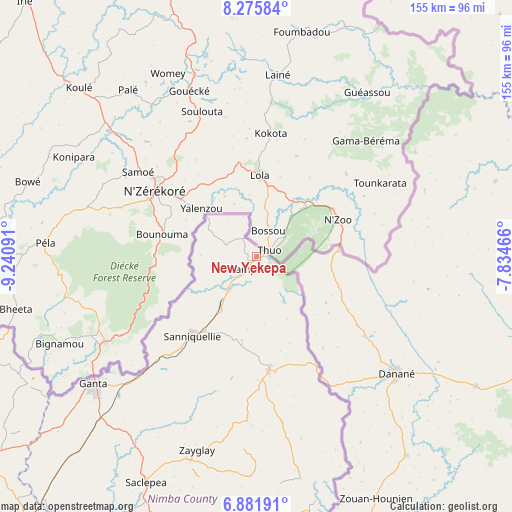
| Upper-left | 8.27584°, | -9.24091° |
| Center: | 7.57944°, | -8.53778° |
| Lower-right: | 6.88191°, | -7.83466° |
| Map W x H: | 155×155 km | = 96.3×96.3mi |
| max Lat: | 8.42194° ⇑5.6% North |
| New Yekepa: | 7.57944° |
| min Lat: | ⇓94.4% South 4.3782° |
| min Long | New Yekepa | max Long |
| -11.3671° | -8.53778° | -7.71081° |
| W 66.7%⇐ | ⇒33.3% E |
Elevation
Elevation of New Yekepa is 510 m = 1673 ft, and this is 330.9 m = 1086 ft above average elevation for this country.
| Max E: |
550 m = 1804 ft | 5.6% |
| New Yekepa | 510 m 1673 ft | |
| Avg. | 179.1 m = 588 ft | |
Min E: |
5 m = 16 ft | 94.4% |
See also: Liberia elevation on elevation.city.
Geographical zone
New Yekepa is located in North Torrid zone (between Equator and Tropic of Cancer). Distance of Equator is 842.8 km =523.7 mi to South.| Distance of | km | miles | from New Yekepa |
|---|---|---|---|
| North Pole | 9164.3 | 5694.4 | to North |
| Arctic Circle | 6558.4 | 4075.2 | to North |
| Tropic Cancer | 1763.2 | 1095.6 | to North |
| Equator | 842.8 | 523.7 | to South |


Nearby cities:
15 places around New Yekepa: (largest is in red/bold)
• Bensonville
261.3 km =162.4 mi,  241°
241°
• Bopolu
222.4 km =138.2 mi,  255°
255°
• Buchanan
252.4 km =156.8 mi,  221°
221°
• Buutuo
86.3 km =53.6 mi,  165°
165°
• Cestos City
262.7 km =163.2 mi,  206°
206°
• Fish Town
274.8 km =170.8 mi,  164°
164°
• Ganta
30.8 km =19.1 mi,  178°
178°
• Gbarnga
121.7 km =75.6 mi, 237°
• Greenville
290.9 km =180.8 mi,  190°
190°
• Kakata
231.8 km =144 mi, 239°
• Monrovia
287 km =178.3 mi, 240°
• Sanniquellie
31 km =19.3 mi, 218°
• Tubmanburg
263.9 km =164 mi,  252°
252°
• Voinjama
162.9 km =101.2 mi,  305°
305°
• Zwedru
173.8 km =108 mi, 165°
Sources, notices
• [Note1] Compared only with cities in Liberia existing in our database
• [Src1] Map data: © OpenStreetMap contributors (CC-BY-SA)
• [Src2] Other city data from geonames.org with taken over terms of usage.
• [Src3] Geographical zone / Annual Mean Temperature by Robert A. Rohde @ Wikipedia
