Ranohira geodata
Ranohira (Ihorombe) is a populated place; located in Madagascar in Indian/Antananarivo (GMT+3) time zone. With population of 6,000 people, there are 106 cities with bigger population in this country. Compared to other cities in Madagascar, 82.1% of cities are located further ↑North; 85.4% of cities are located further →East and 62.6% of cities have lower elevation than Ranohira. Note1
Administrative division(s):
- Level 1: Ihorombe
- Level 2: Ihosy
- Level 3: Ranohira
- Level 4: Ranohira Basse


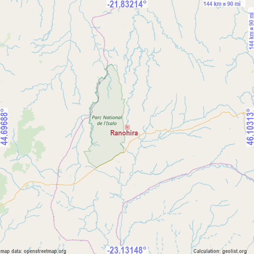
Ranohira GPS coordinates[2]
22° 28' 59.988" South, 45° 24' 0" East
| Map corner | latitude | longitude |
|---|---|---|
| Upper-left | -21.83214°, | 44.69688° |
| Center: | -22.48333°, | 45.4° |
| Lower-right: | -23.13148°, | 46.10313° |
| Map W x H: | 144.5×144.5 km | = 89.8×89.8mi |
| max Lat: | -12.31732° ⇑82.1% North |
| Ranohira: | -22.48333° |
| min Lat: | ⇓17.9% South -25.3° |
| min Long | Ranohira | max Long |
| 43.65° | 45.4° | 50.27876° |
| W 14.6%⇐ | ⇒85.4% E |
Elevation
Elevation of Ranohira is 723 m = 2372 ft, and this is 165.6 m = 543 ft above average elevation for this country.
| Max E: |
1763 m = 5784 ft | 37.4% |
| Ranohira | 723 m 2372 ft | |
| Avg. | 557.4 m = 1829 ft | |
Min E: |
1 m = 3 ft | 62.6% |
See also: Madagascar elevation on elevation.city.
Geographical zone
Ranohira is located in South Torrid zone (between Equator and Tropic of Capricorn). Distance of this Southern Tropic circle is 106 km =65.9 mi to South.| Distance of | km | miles | from Ranohira |
|---|---|---|---|
| Equator | 2499.9 | 1553.4 | to North |
| Tropic Capricorn | 106 | 65.9 | to South |
| Antarctic Circle | 4901.3 | 3045.5 | to South |
| South Pole | 7507.1 | 4664.7 | to South |


Nearby cities:
15 places around Ranohira: (largest is in red/bold)
• Ambalasoa
93.5 km =58.1 mi,  138°
138°
• Ambalavao
173.7 km =107.9 mi,  65°
65°
• Anandravy
207 km =128.6 mi,  102°
102°
• Ankazoabo
93.5 km =58.1 mi,  283°
283°
• Antanimena
178.2 km =110.7 mi,  228°
228°
• Behompy
180.2 km =112 mi,  241°
241°
• Beroroha
93.9 km =58.3 mi,  345°
345°
• Betioky
172.6 km =107.2 mi,  217°
217°
• Fianarantsoa
208.2 km =129.4 mi,  56°
56°
• Ihosy
75.1 km =46.7 mi,  83°
83°
• Ikalamavony
192.1 km =119.4 mi,  39°
39°
• Manja
160.4 km =99.7 mi,  316°
316°
• Sakaraha
100.3 km =62.3 mi, 242°
• Toliara
202 km =125.5 mi, 241°
• Vondrozo
196.8 km =122.3 mi, 100°
Sources, notices
• [Note1] Compared only with cities in Madagascar existing in our database
• [Src1] Map data: © OpenStreetMap contributors (CC-BY-SA)
• [Src2] Other city data from geonames.org with taken over terms of usage.
• [Src3] Geographical zone / Annual Mean Temperature by Robert A. Rohde @ Wikipedia
