Ihosy geodata
Ihosy (Ihorombe) is a seat of a first-order administrative division; located in Madagascar in Indian/Antananarivo (GMT+3) time zone. With population of 16,990 people, there are 75 cities with bigger population in this country. Compared to other cities in Madagascar, 81.3% of cities are located further ↑North; 78.9% of cities are located further →East and 63.4% of cities have lower elevation than Ihosy. Note1


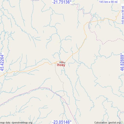
Ihosy GPS coordinates[2]
22° 24' 10.548" South, 46° 7' 32.736" East
| Map corner | latitude | longitude |
|---|---|---|
| Upper-left | -21.75136°, | 45.42264° |
| Center: | -22.40293°, | 46.12576° |
| Lower-right: | -23.05146°, | 46.82889° |
| Map W x H: | 144.6×144.6 km | = 89.9×89.9mi |
| max Lat: | -12.31732° ⇑81.3% North |
| Ihosy: | -22.40293° |
| min Lat: | ⇓18.7% South -25.3° |
| min Long | Ihosy | max Long |
| 43.65° | 46.12576° | 50.27876° |
| W 21.1%⇐ | ⇒78.9% E |
Elevation
Elevation of Ihosy is 733 m = 2405 ft, and this is 175.6 m = 576 ft above average elevation for this country.
| Max E: |
1763 m = 5784 ft | 36.6% |
| Ihosy | 733 m 2405 ft | |
| Avg. | 557.4 m = 1829 ft | |
Min E: |
1 m = 3 ft | 63.4% |
See also: Madagascar elevation on elevation.city.
Geographical zone
Ihosy is located in South Torrid zone (between Equator and Tropic of Capricorn). Distance of this Southern Tropic circle is 114.9 km =71.4 mi to South.| Distance of | km | miles | from Ihosy |
|---|---|---|---|
| Equator | 2491 | 1547.8 | to North |
| Tropic Capricorn | 114.9 | 71.4 | to South |
| Antarctic Circle | 4910.2 | 3051.1 | to South |
| South Pole | 7516.1 | 4670.3 | to South |


Nearby cities:
15 places around Ihosy: (largest is in red/bold)
• Ambalasoa
80.4 km =50 mi,  189°
189°
• Ambalavao
104.6 km =65 mi,  52°
52°
• Anandravy
138.8 km =86.2 mi,  113°
113°
• Ankazoabo
166 km =103.1 mi,  274°
274°
• Beroroha
128.3 km =79.7 mi,  309°
309°
• Fandrandava
152.2 km =94.6 mi, 49°
• Fianarantsoa
144.8 km =90 mi,  43°
43°
• Ifatsy
167 km =103.8 mi,  89°
89°
• Ikalamavony
147.1 km =91.4 mi,  18°
18°
• Ikongo
146.5 km =91 mi,  66°
66°
• Manato
139.6 km =86.7 mi, 89°
• Ranohira
75.1 km =46.7 mi,  263°
263°
• Sakaraha
172.5 km =107.2 mi,  251°
251°
• Vohimanitra
180.1 km =111.9 mi,  64°
64°
• Vondrozo
127.4 km =79.2 mi, 111°
Sources, notices
• [Note1] Compared only with cities in Madagascar existing in our database
• [Src1] Map data: © OpenStreetMap contributors (CC-BY-SA)
• [Src2] Other city data from geonames.org with taken over terms of usage.
• [Src3] Geographical zone / Annual Mean Temperature by Robert A. Rohde @ Wikipedia
