Vangaindrano geodata
Vangaindrano (Atsimo-Atsinanana) is a populated place; located in Madagascar in Indian/Antananarivo (GMT+3) time zone. With population of 23,523 people, there are 53 cities with bigger population in this country. Compared to other cities in Madagascar, 88.6% of cities are located further ↑North; 51.2% of cities are located further →East and 85.4% of cities have higher elevation than Vangaindrano. Note1
Administrative division(s):
- Level 1: Atsimo-Atsinanana
- Level 2: Vangaindrano District
- Level 3: Vangaindrano
- Level 4: Morafeno


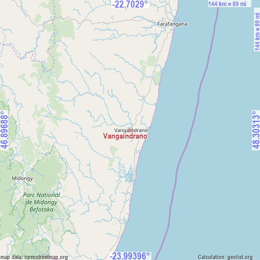
Vangaindrano GPS coordinates[2]
23° 21' 0" South, 47° 36' 0" East
| Map corner | latitude | longitude |
|---|---|---|
| Upper-left | -22.7029°, | 46.89688° |
| Center: | -23.35°, | 47.6° |
| Lower-right: | -23.99396°, | 48.30313° |
| Map W x H: | 143.6×143.6 km | = 89.2×89.2mi |
| max Lat: | -12.31732° ⇑88.6% North |
| Vangaindrano: | -23.35° |
| min Lat: | ⇓11.4% South -25.3° |
| min Long | Vangaindrano | max Long |
| 43.65° | 47.6° | 50.27876° |
| W 48.8%⇐ | ⇒51.2% E |
Elevation
Elevation of Vangaindrano is 13 m = 43 ft, and this is 544.4 m = 1786 ft below average elevation for this country.
| Max E: |
1763 m = 5784 ft | 85.4% |
| Avg. | 557.4 m = 1829 ft | |
| Vangaindrano | 13 m = 43 ft | |
Min E: |
1 m = 3 ft | 14.6% |
See also: Madagascar elevation on elevation.city.
Geographical zone
Vangaindrano is located in South Torrid zone (between Equator and Tropic of Capricorn). Distance of this Southern Tropic circle is 9.6 km =6 mi to South.| Distance of | km | miles | from Vangaindrano |
|---|---|---|---|
| Equator | 2596.3 | 1613.3 | to North |
| Tropic Capricorn | 9.6 | 6 | to South |
| Antarctic Circle | 4804.9 | 2985.6 | to South |
| South Pole | 7410.8 | 4604.9 | to South |


Nearby cities:
15 places around Vangaindrano: (largest is in red/bold)
• Ambalasoa
165.5 km =102.8 mi,  279°
279°
• Ambalavao
182 km =113.1 mi,  337°
337°
• Amboanjo
152.3 km =94.6 mi,  9°
9°
• Anandravy
55.4 km =34.4 mi,  334°
334°
• Farafangana
63.1 km =39.2 mi,  21°
21°
• Ifatsy
106.7 km =66.3 mi, 8°
• Ihosy
184.1 km =114.4 mi,  304°
304°
• Ikongo
164 km =101.9 mi,  354°
354°
• Manakara
140.1 km =87.1 mi, 17°
• Manato
106.3 km =66.1 mi, 353°
• Savana
111.8 km =69.5 mi, 15°
• Tôlanaro
197.3 km =122.6 mi,  198°
198°
• Vohimanitra
183.8 km =114.2 mi,  3°
3°
• Vohipaho
24.5 km =15.2 mi, 204°
• Vondrozo
67.6 km =42 mi, 331°
Sources, notices
• [Note1] Compared only with cities in Madagascar existing in our database
• [Src1] Map data: © OpenStreetMap contributors (CC-BY-SA)
• [Src2] Other city data from geonames.org with taken over terms of usage.
• [Src3] Geographical zone / Annual Mean Temperature by Robert A. Rohde @ Wikipedia
