Farafangana geodata
Farafangana (Atsimo-Atsinanana) is a seat of a first-order administrative division; located in Madagascar in Indian/Antananarivo (GMT+3) time zone. With population of 24,764 people, there are 49 cities with bigger population in this country. Compared to other cities in Madagascar, 83.7% of cities are located further ↑North; 61.8% of cities are located further ←West and 87% of cities have higher elevation than Farafangana. Note1


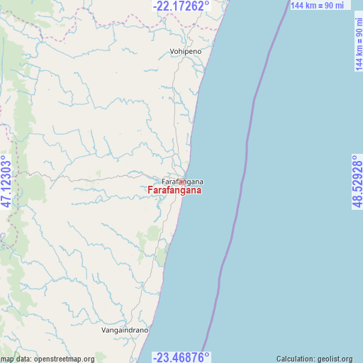
Farafangana GPS coordinates[2]
22° 49' 20.028" South, 47° 49' 34.14" East
| Map corner | latitude | longitude |
|---|---|---|
| Upper-left | -22.17262°, | 47.12303° |
| Center: | -22.82223°, | 47.82615° |
| Lower-right: | -23.46876°, | 48.52928° |
| Map W x H: | 144.1×144.1 km | = 89.5×89.5mi |
| max Lat: | -12.31732° ⇑83.7% North |
| Farafangana: | -22.82223° |
| min Lat: | ⇓16.3% South -25.3° |
| min Long | Farafangana | max Long |
| 43.65° | 47.82615° | 50.27876° |
| W 61.8%⇐ | ⇒38.2% E |
Elevation
Elevation of Farafangana is 12 m = 39 ft, and this is 545.4 m = 1789 ft below average elevation for this country.
| Max E: |
1763 m = 5784 ft | 87% |
| Avg. | 557.4 m = 1829 ft | |
| Farafangana | 12 m = 39 ft | |
Min E: |
1 m = 3 ft | 13% |
See also: Madagascar elevation on elevation.city.
Geographical zone
Farafangana is located in South Torrid zone (between Equator and Tropic of Capricorn). Distance of this Southern Tropic circle is 68.3 km =42.4 mi to South.| Distance of | km | miles | from Farafangana |
|---|---|---|---|
| Equator | 2537.6 | 1576.8 | to North |
| Tropic Capricorn | 68.3 | 42.4 | to South |
| Antarctic Circle | 4863.6 | 3022.1 | to South |
| South Pole | 7469.5 | 4641.3 | to South |


Nearby cities:
15 places around Farafangana: (largest is in red/bold)
• Ambalavao
143.3 km =89 mi,  320°
320°
• Amboanjo
91.5 km =56.9 mi,  1°
1°
• Anandravy
47.9 km =29.8 mi,  259°
259°
• Fandrandava
156.8 km =97.4 mi,  337°
337°
• Fianarantsoa
170.3 km =105.8 mi,  333°
333°
• Ifanadiana
170.4 km =105.9 mi,  353°
353°
• Ifatsy
47.6 km =29.6 mi, 350°
• Ikongo
111.9 km =69.5 mi, 338°
• Manakara
77.3 km =48 mi,  14°
14°
• Manato
58.7 km =36.5 mi, 323°
• Savana
49.4 km =30.7 mi, 8°
• Vangaindrano
63.1 km =39.2 mi,  201°
201°
• Vohimanitra
125.5 km =78 mi, 354°
• Vohipaho
87.5 km =54.4 mi, 202°
• Vondrozo
55.6 km =34.5 mi,  270°
270°
Sources, notices
• [Note1] Compared only with cities in Madagascar existing in our database
• [Src1] Map data: © OpenStreetMap contributors (CC-BY-SA)
• [Src2] Other city data from geonames.org with taken over terms of usage.
• [Src3] Geographical zone / Annual Mean Temperature by Robert A. Rohde @ Wikipedia
