Vohipaho geodata
Vohipaho (Atsimo-Atsinanana) is a populated place; located in Madagascar in Indian/Antananarivo (GMT+3) time zone. With population of 27,000 people, there are 41 cities with bigger population in this country. Compared to other cities in Madagascar, 90.2% of cities are located further ↑North; 53.7% of cities are located further →East and 82.9% of cities have higher elevation than Vohipaho. Note1
Administrative division(s):
- Level 1: Atsimo-Atsinanana
- Level 2: Vangaindrano District
- Level 3: Vohipaho
- Level 4: Vohipaho


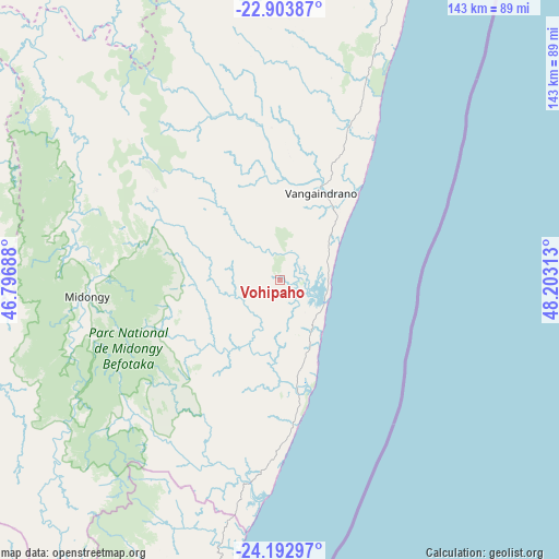
Vohipaho GPS coordinates[2]
23° 33' 0" South, 47° 30' 0" East
| Map corner | latitude | longitude |
|---|---|---|
| Upper-left | -22.90387°, | 46.79688° |
| Center: | -23.55°, | 47.5° |
| Lower-right: | -24.19297°, | 48.20313° |
| Map W x H: | 143.3×143.3 km | = 89×89mi |
| max Lat: | -12.31732° ⇑90.2% North |
| Vohipaho: | -23.55° |
| min Lat: | ⇓9.8% South -25.3° |
| min Long | Vohipaho | max Long |
| 43.65° | 47.5° | 50.27876° |
| W 46.3%⇐ | ⇒53.7% E |
Elevation
Elevation of Vohipaho is 14 m = 46 ft, and this is 543.4 m = 1783 ft below average elevation for this country.
| Max E: |
1763 m = 5784 ft | 82.9% |
| Avg. | 557.4 m = 1829 ft | |
| Vohipaho | 14 m = 46 ft | |
Min E: |
1 m = 3 ft | 17.1% |
See also: Madagascar elevation on elevation.city.
Geographical zone
Vohipaho is located in South temperate zone (between Tropic of Capricorn and the Antarctic Circle). Distance of this Southern Tropic circle is 12.6 km =7.8 mi to North.| Distance of | km | miles | from Vohipaho |
|---|---|---|---|
| Equator | 2618.5 | 1627.1 | to North |
| Tropic Capricorn | 12.6 | 7.8 | to North |
| Antarctic Circle | 4782.7 | 2971.8 | to South |
| South Pole | 7388.5 | 4591 | to South |


Nearby cities:
15 places around Vohipaho: (largest is in red/bold)
• Ambalasoa
160.5 km =99.7 mi,  287°
287°
• Ambalavao
199.5 km =124 mi,  343°
343°
• Amboanjo
176 km =109.4 mi,  11°
11°
• Amboasary
180 km =111.8 mi,  241°
241°
• Anandravy
73.5 km =45.7 mi,  349°
349°
• Farafangana
87.5 km =54.4 mi,  22°
22°
• Ifatsy
130.4 km =81 mi, 11°
• Ihosy
189.9 km =118 mi,  312°
312°
• Ikongo
185.4 km =115.2 mi,  357°
357°
• Manakara
164.4 km =102.2 mi, 18°
• Manato
127.9 km =79.5 mi, 359°
• Savana
136 km =84.5 mi, 17°
• Tôlanaro
173 km =107.5 mi,  197°
197°
• Vangaindrano
24.5 km =15.2 mi, 24°
• Vondrozo
84.5 km =52.5 mi, 344°
Sources, notices
• [Note1] Compared only with cities in Madagascar existing in our database
• [Src1] Map data: © OpenStreetMap contributors (CC-BY-SA)
• [Src2] Other city data from geonames.org with taken over terms of usage.
• [Src3] Geographical zone / Annual Mean Temperature by Robert A. Rohde @ Wikipedia
