Mejit geodata
Mejit (Mejit Island) is a seat of a first-order administrative division; located in Marshall Islands in Pacific/Majuro (GMT+12) time zone. With population of 300 people, there are 15 cities with bigger population in this country. Compared to other cities in Marshall Islands, 87.5% of cities are located further ↓South; 75% of cities are located further ←West and 79.2% of cities have lower elevation than Mejit. Note1


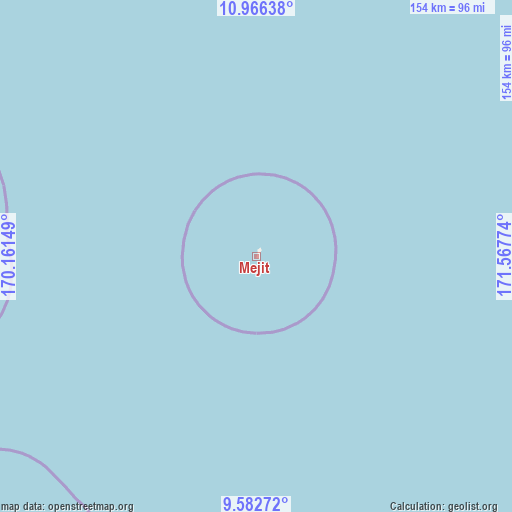
Mejit GPS coordinates[2]
10° 16' 31.116" North, 170° 51' 52.596" East
| Map corner | latitude | longitude |
|---|---|---|
| Upper-left | 10.96638°, | 170.16149° |
| Center: | 10.27531°, | 170.86461° |
| Lower-right: | 9.58272°, | 171.56774° |
| Map W x H: | 153.8×153.9 km | = 95.6×95.6mi |
| max Lat: | 11.34735° ⇑12.5% North |
| Mejit: | 10.27531° |
| min Lat: | ⇓87.5% South 4.58199° |
| min Long | Mejit | max Long |
| 162.33733° | 170.86461° | 171.73502° |
| W 75%⇐ | ⇒25% E |
Elevation
Elevation of Mejit is 13 m = 43 ft, and this is 3.3 m = 11 ft above average elevation for this country.
| Max E: |
16 m = 52 ft | 20.8% |
| Mejit | 13 m 43 ft | |
| Avg. | 9.7 m = 32 ft | |
Min E: |
5 m = 16 ft | 79.2% |
See also: Marshall Islands elevation on elevation.city.
Geographical zone
Mejit is located in North Torrid zone (between Equator and Tropic of Cancer). Distance of Equator is 1142.5 km =709.9 mi to South.| Distance of | km | miles | from Mejit |
|---|---|---|---|
| North Pole | 8864.6 | 5508.2 | to North |
| Arctic Circle | 6258.7 | 3889 | to North |
| Tropic Cancer | 1463.4 | 909.3 | to North |
| Equator | 1142.5 | 709.9 | to South |


Nearby cities:
13 places around Mejit: (largest is in red/bold)
• Ailuk
97 km =60.3 mi,  266°
266°
• Airuk
402 km =249.8 mi,  213°
213°
• Arno
364.7 km =226.6 mi,  168°
168°
• Aur
238.7 km =148.3 mi, 171°
• Ebaye
381.2 km =236.9 mi,  244°
244°
• Jabat
349.1 km =216.9 mi,  216°
216°
• Likiep
177.3 km =110.2 mi,  253°
253°
• Loen
402.3 km =250 mi,  225°
225°
• Majuro
358.7 km =222.9 mi, 170°
• RMI Capitol
358.8 km =222.9 mi, 170°
• Taroa
179 km =111.2 mi, 167°
• Utrik
153.5 km =95.4 mi,  313°
313°
• Wotje
114.3 km =71 mi, 216°
Sources, notices
• [Note1] Compared only with cities in Marshall Islands existing in our database
• [Src1] Map data: © OpenStreetMap contributors (CC-BY-SA)
• [Src2] Other city data from geonames.org with taken over terms of usage.
• [Src3] Geographical zone / Annual Mean Temperature by Robert A. Rohde @ Wikipedia
