Ebaye geodata
Ebaye (Kwajalein Atoll) is a seat of a first-order administrative division; located in Marshall Islands in Pacific/Kwajalein (GMT+12) time zone. With population of 15,000 people, there is 1 city with bigger population in this country. Compared to other cities in Marshall Islands, 58.3% of cities are located further ↓South; 75% of cities are located further →East and 95.8% of cities have higher elevation than Ebaye. Note1


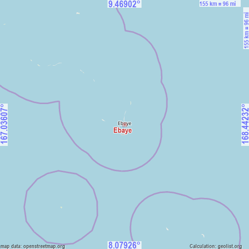
Ebaye GPS coordinates[2]
8° 46' 29.244" North, 167° 44' 21.084" East
| Map corner | latitude | longitude |
|---|---|---|
| Upper-left | 9.46902°, | 167.03607° |
| Center: | 8.77479°, | 167.73919° |
| Lower-right: | 8.07926°, | 168.44232° |
| Map W x H: | 154.5×154.5 km | = 96×96mi |
| max Lat: | 11.34735° ⇑41.7% North |
| Ebaye: | 8.77479° |
| min Lat: | ⇓58.3% South 4.58199° |
| min Long | Ebaye | max Long |
| 162.33733° | 167.73919° | 171.73502° |
| W 25%⇐ | ⇒75% E |
Elevation
Elevation of Ebaye is 6 m = 20 ft, and this is 3.7 m = 12 ft below average elevation for this country.
| Max E: |
16 m = 52 ft | 95.8% |
| Avg. | 9.7 m = 32 ft | |
| Ebaye | 6 m = 20 ft | |
Min E: |
5 m = 16 ft | 4.2% |
See also: Marshall Islands elevation on elevation.city.
Geographical zone
Ebaye is located in North Torrid zone (between Equator and Tropic of Cancer). Distance of Equator is 975.7 km =606.3 mi to South.| Distance of | km | miles | from Ebaye |
|---|---|---|---|
| North Pole | 9031.4 | 5611.9 | to North |
| Arctic Circle | 6425.5 | 3992.6 | to North |
| Tropic Cancer | 1630.3 | 1013 | to North |
| Equator | 975.7 | 606.3 | to South |


Nearby cities:
15 places around Ebaye: (largest is in red/bold)
• Ailuk
293.6 km =182.4 mi,  56°
56°
• Airuk
204.7 km =127.2 mi,  144°
144°
• Jabat
177.4 km =110.2 mi,  129°
129°
• Jabor
380.5 km =236.4 mi,  146°
146°
• Kili
380 km =236.1 mi,  156°
156°
• Lae
163 km =101.3 mi,  275°
275°
• Lib
65.1 km =40.5 mi,  217°
217°
• Likiep
208.3 km =129.4 mi, 55°
• Loen
125.1 km =77.7 mi, 154°
• Namdrik
355.3 km =220.8 mi,  173°
173°
• Rongelap
281.3 km =174.8 mi,  340°
340°
• Ujae
217.7 km =135.3 mi,  274°
274°
• Utrik
357.3 km =222 mi,  40°
40°
• Wotho
244.7 km =152 mi,  309°
309°
• Wotje
284.4 km =176.7 mi,  74°
74°
Sources, notices
• [Note1] Compared only with cities in Marshall Islands existing in our database
• [Src1] Map data: © OpenStreetMap contributors (CC-BY-SA)
• [Src2] Other city data from geonames.org with taken over terms of usage.
• [Src3] Geographical zone / Annual Mean Temperature by Robert A. Rohde @ Wikipedia
