Tachilek geodata
Tachilek (Shan) is a populated place; located in Myanmar in Asia/Yangon (GMT+6.5) time zone. With population of 51,553 people, there are 44 cities with bigger population in this country. Compared to other cities in Myanmar, 71.6% of cities are located further ↓South; 100% of cities are located further ←West and 87.8% of cities have lower elevation than Tachilek. Note1


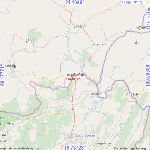
Tachilek GPS coordinates[2]
20° 26' 51" North, 99° 52' 50.988" East
| Map corner | latitude | longitude |
|---|---|---|
| Upper-left | 21.1049°, | 99.17771° |
| Center: | 20.4475°, | 99.88083° |
| Lower-right: | 19.78728°, | 100.58396° |
| Map W x H: | 146.5×146.5 km | = 91×91mi |
| max Lat: | 25.38327° ⇑28.4% North |
| Tachilek: | 20.4475° |
| min Lat: | ⇓71.6% South 9.98238° |
| min Long | Tachilek | max Long |
| 92.89835° | 99.88083° | 99.88083° |
| W 100%⇐ | ⇒0% E |
Elevation
Elevation of Tachilek is 402 m = 1319 ft, and this is 213.1 m = 699 ft above average elevation for this country.
| Max E: |
1768 m = 5801 ft | 12.2% |
| Tachilek | 402 m 1319 ft | |
| Avg. | 188.9 m = 620 ft | |
Min E: |
5 m = 16 ft | 87.8% |
See also: Tachilek elevation on elevation.city.
Geographical zone
Tachilek is located in North Torrid zone (between Equator and Tropic of Cancer). Distance of this Northern Tropic circle is 332.4 km =206.5 mi to North.| Distance of | km | miles | from Tachilek |
|---|---|---|---|
| North Pole | 7733.5 | 4805.4 | to North |
| Arctic Circle | 5127.6 | 3186.1 | to North |
| Tropic Cancer | 332.4 | 206.5 | to North |
| Equator | 2273.5 | 1412.7 | to South |


Nearby cities:
12 places around Tachilek: (largest is in red/bold)
• Indein
316.6 km =196.7 mi,  270°
270°
• Kyaukse
409.5 km =254.5 mi,  288°
288°
• Lashio
353.6 km =219.7 mi,  321°
321°
• Loikaw
291.8 km =181.3 mi,  252°
252°
• Nay Pyi Taw
399.4 km =248.2 mi,  258°
258°
• Nyaungshwe
307.7 km =191.2 mi, 274°
• Pyin Oo Lwin
396.3 km =246.2 mi,  296°
296°
• Pyinmana
391.6 km =243.3 mi, 258°
• Pyu
422 km =262.2 mi,  238°
238°
• Taunggyi
298.3 km =185.4 mi,  277°
277°
• Taungoo
397.7 km =247.1 mi, 245°
• Yamethin
389.9 km =242.3 mi, 269°
Sources, notices
• [Note1] Compared only with cities in Myanmar existing in our database
• [Src1] Map data: © OpenStreetMap contributors (CC-BY-SA)
• [Src2] Other city data from geonames.org with taken over terms of usage.
• [Src3] Geographical zone / Annual Mean Temperature by Robert A. Rohde @ Wikipedia
