Kyaukse geodata
Kyaukse (Mandalay) is a populated place; located in Myanmar in Asia/Yangon (GMT+6.5) time zone. With population of 50,480 people, there are 46 cities with bigger population in this country. Compared to other cities in Myanmar, 83.8% of cities are located further ↓South; 52.7% of cities are located further →East and 73% of cities have lower elevation than Kyaukse. Note1


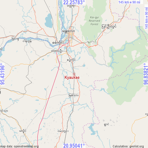
Kyaukse GPS coordinates[2]
21° 36' 20.16" North, 96° 8' 6.288" East
| Map corner | latitude | longitude |
|---|---|---|
| Upper-left | 22.25783°, | 95.43196° |
| Center: | 21.6056°, | 96.13508° |
| Lower-right: | 20.95041°, | 96.83821° |
| Map W x H: | 145.4×145.4 km | = 90.3×90.3mi |
| max Lat: | 25.38327° ⇑16.2% North |
| Kyaukse: | 21.6056° |
| min Lat: | ⇓83.8% South 9.98238° |
| min Long | Kyaukse | max Long |
| 92.89835° | 96.13508° | 99.88083° |
| W 47.3%⇐ | ⇒52.7% E |
Elevation
Elevation of Kyaukse is 86 m = 282 ft, and this is 102.9 m = 338 ft below average elevation for this country.
| Max E: |
1768 m = 5801 ft | 27% |
| Avg. | 188.9 m = 620 ft | |
| Kyaukse | 86 m = 282 ft | |
Min E: |
5 m = 16 ft | 73% |
See also: Kyaukse elevation on elevation.city.
Geographical zone
Kyaukse is located in North Torrid zone (between Equator and Tropic of Cancer). Distance of this Northern Tropic circle is 203.6 km =126.5 mi to North.| Distance of | km | miles | from Kyaukse |
|---|---|---|---|
| North Pole | 7604.7 | 4725.3 | to North |
| Arctic Circle | 4998.9 | 3106.2 | to North |
| Tropic Cancer | 203.6 | 126.5 | to North |
| Equator | 2402.3 | 1492.7 | to South |


Nearby cities:
15 places around Kyaukse: (largest is in red/bold)
• Chauk
157.5 km =97.9 mi,  240°
240°
• Indein
146.9 km =91.3 mi,  150°
150°
• Mandalay
41.4 km =25.7 mi,  352°
352°
• Meiktila
85.9 km =53.4 mi,  199°
199°
• Mogok
150.9 km =93.8 mi,  14°
14°
• Monywa
117.3 km =72.9 mi,  298°
298°
• Myingyan
78.9 km =49 mi,  258°
258°
• Nyaungshwe
133.8 km =83.1 mi,  141°
141°
• Pakokku
112.8 km =70.1 mi,  254°
254°
• Pyin Oo Lwin
58.2 km =36.2 mi,  34°
34°
• Sagaing
34.3 km =21.3 mi,  332°
332°
• Shwebo
116.2 km =72.2 mi,  337°
337°
• Taunggyi
130.4 km =81 mi,  134°
134°
• Yamethin
130.5 km =81.1 mi,  179°
179°
• Yenangyaung
182.4 km =113.3 mi,  225°
225°
Sources, notices
• [Note1] Compared only with cities in Myanmar existing in our database
• [Src1] Map data: © OpenStreetMap contributors (CC-BY-SA)
• [Src2] Other city data from geonames.org with taken over terms of usage.
• [Src3] Geographical zone / Annual Mean Temperature by Robert A. Rohde @ Wikipedia
