Yamethin geodata
Yamethin (Mandalay) is a populated place; located in Myanmar in Asia/Yangon (GMT+6.5) time zone. With population of 59,867 people, there are 36 cities with bigger population in this country. Compared to other cities in Myanmar, 70.3% of cities are located further ↓South; 51.4% of cities are located further →East and 83.8% of cities have lower elevation than Yamethin. Note1


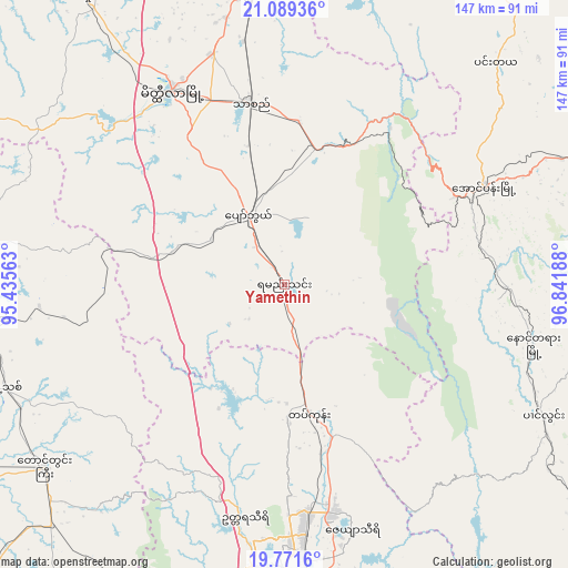
Yamethin GPS coordinates[2]
20° 25' 54.804" North, 96° 8' 19.5" East
| Map corner | latitude | longitude |
|---|---|---|
| Upper-left | 21.08936°, | 95.43563° |
| Center: | 20.43189°, | 96.13875° |
| Lower-right: | 19.7716°, | 96.84188° |
| Map W x H: | 146.5×146.5 km | = 91×91mi |
| max Lat: | 25.38327° ⇑29.7% North |
| Yamethin: | 20.43189° |
| min Lat: | ⇓70.3% South 9.98238° |
| min Long | Yamethin | max Long |
| 92.89835° | 96.13875° | 99.88083° |
| W 48.6%⇐ | ⇒51.4% E |
Elevation
Elevation of Yamethin is 203 m = 666 ft, and this is 14.1 m = 46 ft above average elevation for this country.
| Max E: |
1768 m = 5801 ft | 16.2% |
| Yamethin | 203 m 666 ft | |
| Avg. | 188.9 m = 620 ft | |
Min E: |
5 m = 16 ft | 83.8% |
See also: Yamethin elevation on elevation.city.
Geographical zone
Yamethin is located in North Torrid zone (between Equator and Tropic of Cancer). Distance of this Northern Tropic circle is 334.1 km =207.6 mi to North.| Distance of | km | miles | from Yamethin |
|---|---|---|---|
| North Pole | 7735.2 | 4806.4 | to North |
| Arctic Circle | 5129.4 | 3187.3 | to North |
| Tropic Cancer | 334.1 | 207.6 | to North |
| Equator | 2271.8 | 1411.6 | to South |


Nearby cities:
15 places around Yamethin: (largest is in red/bold)
• Chauk
146.9 km =91.3 mi,  290°
290°
• Indein
73.3 km =45.5 mi,  87°
87°
• Kyaukse
130.5 km =81.1 mi,  359°
359°
• Loikaw
139.8 km =86.9 mi,  126°
126°
• Magway
129.7 km =80.6 mi,  255°
255°
• Meiktila
57.5 km =35.7 mi,  329°
329°
• Minbu
134.6 km =83.6 mi, 258°
• Myingyan
138.3 km =85.9 mi, 325°
• Nay Pyi Taw
76.4 km =47.5 mi,  180°
180°
• Nyaungshwe
86.6 km =53.8 mi,  72°
72°
• Pakokku
148.6 km =92.3 mi,  312°
312°
• Pyinmana
77.5 km =48.2 mi,  174°
174°
• Taungdwingyi
77.9 km =48.4 mi,  232°
232°
• Taunggyi
101.6 km =63.1 mi, 66°
• Yenangyaung
132.1 km =82.1 mi,  271°
271°
Sources, notices
• [Note1] Compared only with cities in Myanmar existing in our database
• [Src1] Map data: © OpenStreetMap contributors (CC-BY-SA)
• [Src2] Other city data from geonames.org with taken over terms of usage.
• [Src3] Geographical zone / Annual Mean Temperature by Robert A. Rohde @ Wikipedia
