Taunggyi geodata
Taunggyi (Shan) is a seat of a first-order administrative division; located in Myanmar in Asia/Yangon (GMT+6.5) time zone. With population of 160,115 people, there are 11 cities with bigger population in this country. Compared to other cities in Myanmar, 77% of cities are located further ↓South; 70.3% of cities are located further ←West and 97.3% of cities have lower elevation than Taunggyi. Note1


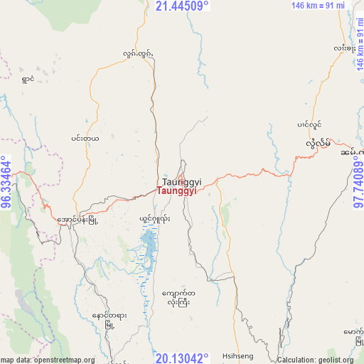
Taunggyi GPS coordinates[2]
20° 47' 21.084" North, 97° 2' 15.936" East
| Map corner | latitude | longitude |
|---|---|---|
| Upper-left | 21.44509°, | 96.33464° |
| Center: | 20.78919°, | 97.03776° |
| Lower-right: | 20.13042°, | 97.74089° |
| Map W x H: | 146.2×146.2 km | = 90.8×90.8mi |
| max Lat: | 25.38327° ⇑23% North |
| Taunggyi: | 20.78919° |
| min Lat: | ⇓77% South 9.98238° |
| min Long | Taunggyi | max Long |
| 92.89835° | 97.03776° | 99.88083° |
| W 70.3%⇐ | ⇒29.7% E |
Elevation
Elevation of Taunggyi is 1396 m = 4580 ft, and this is 1207.1 m = 3960 ft above average elevation for this country.
| Max E: |
1768 m = 5801 ft | 2.7% |
| Taunggyi | 1396 m 4580 ft | |
| Avg. | 188.9 m = 620 ft | |
Min E: |
5 m = 16 ft | 97.3% |
See also: Taunggyi elevation on elevation.city.
Geographical zone
Taunggyi is located in North Torrid zone (between Equator and Tropic of Cancer). Distance of this Northern Tropic circle is 294.4 km =182.9 mi to North.| Distance of | km | miles | from Taunggyi |
|---|---|---|---|
| North Pole | 7695.5 | 4781.8 | to North |
| Arctic Circle | 5089.6 | 3162.5 | to North |
| Tropic Cancer | 294.4 | 182.9 | to North |
| Equator | 2311.5 | 1436.3 | to South |


Nearby cities:
15 places around Taunggyi: (largest is in red/bold)
• Indein
41.8 km =26 mi,  209°
209°
• Kyaukse
130.4 km =81 mi,  314°
314°
• Loikaw
124.9 km =77.6 mi,  171°
171°
• Mandalay
164.7 km =102.3 mi,  323°
323°
• Meiktila
122.9 km =76.4 mi,  274°
274°
• Myingyan
186.6 km =115.9 mi,  293°
293°
• Nay Pyi Taw
149.8 km =93.1 mi,  219°
219°
• Nyaungshwe
17.9 km =11.1 mi, 217°
• Pakokku
211.6 km =131.5 mi, 286°
• Pyin Oo Lwin
151 km =93.8 mi,  336°
336°
• Pyinmana
145.5 km =90.4 mi, 216°
• Sagaing
163.4 km =101.5 mi, 317°
• Taungdwingyi
178.2 km =110.7 mi,  240°
240°
• Taungoo
214.8 km =133.5 mi,  197°
197°
• Yamethin
101.6 km =63.1 mi,  246°
246°
Sources, notices
• [Note1] Compared only with cities in Myanmar existing in our database
• [Src1] Map data: © OpenStreetMap contributors (CC-BY-SA)
• [Src2] Other city data from geonames.org with taken over terms of usage.
• [Src3] Geographical zone / Annual Mean Temperature by Robert A. Rohde @ Wikipedia
