Pyinmana geodata
Pyinmana (Nay Pyi Taw) is a populated place; located in Myanmar in Asia/Yangon (GMT+6.5) time zone. With population of 97,409 people, there are 23 cities with bigger population in this country. Compared to other cities in Myanmar, 62.2% of cities are located further ↓South; 51.4% of cities are located further ←West and 74.3% of cities have lower elevation than Pyinmana. Note1


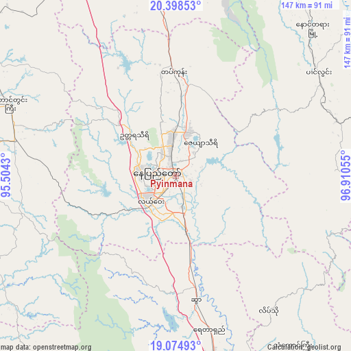
Pyinmana GPS coordinates[2]
19° 44' 17.16" North, 96° 12' 26.712" East
| Map corner | latitude | longitude |
|---|---|---|
| Upper-left | 20.39853°, | 95.5043° |
| Center: | 19.7381°, | 96.20742° |
| Lower-right: | 19.07493°, | 96.91055° |
| Map W x H: | 147.2×147.2 km | = 91.5×91.5mi |
| max Lat: | 25.38327° ⇑37.8% North |
| Pyinmana: | 19.7381° |
| min Lat: | ⇓62.2% South 9.98238° |
| min Long | Pyinmana | max Long |
| 92.89835° | 96.20742° | 99.88083° |
| W 51.4%⇐ | ⇒48.6% E |
Elevation
Elevation of Pyinmana is 101 m = 331 ft, and this is 87.9 m = 288 ft below average elevation for this country.
| Max E: |
1768 m = 5801 ft | 25.7% |
| Avg. | 188.9 m = 620 ft | |
| Pyinmana | 101 m = 331 ft | |
Min E: |
5 m = 16 ft | 74.3% |
See also: Pyinmana elevation on elevation.city.
Geographical zone
Pyinmana is located in North Torrid zone (between Equator and Tropic of Cancer). Distance of this Northern Tropic circle is 411.2 km =255.5 mi to North.| Distance of | km | miles | from Pyinmana |
|---|---|---|---|
| North Pole | 7812.4 | 4854.4 | to North |
| Arctic Circle | 5206.5 | 3235.2 | to North |
| Tropic Cancer | 411.2 | 255.5 | to North |
| Equator | 2194.7 | 1363.7 | to South |


Nearby cities:
15 places around Pyinmana: (largest is in red/bold)
• Indein
104.1 km =64.7 mi,  39°
39°
• Loikaw
105.1 km =65.3 mi,  93°
93°
• Magway
140.9 km =87.6 mi,  288°
288°
• Meiktila
131.8 km =81.9 mi,  343°
343°
• Minbu
147.6 km =91.7 mi, 289°
• Myaydo
111.8 km =69.5 mi,  248°
248°
• Nay Pyi Taw
8.2 km =5.1 mi,  275°
275°
• Nyaungshwe
127.6 km =79.3 mi, 36°
• Pyay
144.9 km =90 mi,  225°
225°
• Pyu
141.8 km =88.1 mi,  170°
170°
• Taungdwingyi
75.4 km =46.9 mi, 293°
• Taunggyi
145.5 km =90.4 mi, 36°
• Taungoo
91.6 km =56.9 mi,  164°
164°
• Thayetmyo
117 km =72.7 mi, 246°
• Yamethin
77.5 km =48.2 mi,  354°
354°
Sources, notices
• [Note1] Compared only with cities in Myanmar existing in our database
• [Src1] Map data: © OpenStreetMap contributors (CC-BY-SA)
• [Src2] Other city data from geonames.org with taken over terms of usage.
• [Src3] Geographical zone / Annual Mean Temperature by Robert A. Rohde @ Wikipedia
