Indein geodata
Indein (Shan) is a populated place; located in Myanmar in Asia/Yangon (GMT+6.5) time zone. With population of 600 people, there are 74 cities with bigger population in this country. Compared to other cities in Myanmar, 73% of cities are located further ↓South; 66.2% of cities are located further ←West and 93.2% of cities have lower elevation than Indein. Note1


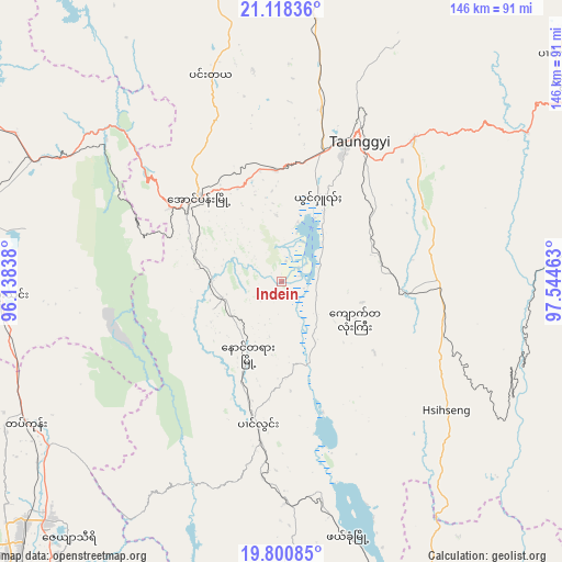
Indein GPS coordinates[2]
20° 27' 39.672" North, 96° 50' 29.4" East
| Map corner | latitude | longitude |
|---|---|---|
| Upper-left | 21.11836°, | 96.13838° |
| Center: | 20.46102°, | 96.8415° |
| Lower-right: | 19.80085°, | 97.54463° |
| Map W x H: | 146.5×146.5 km | = 91×91mi |
| max Lat: | 25.38327° ⇑27% North |
| Indein: | 20.46102° |
| min Lat: | ⇓73% South 9.98238° |
| min Long | Indein | max Long |
| 92.89835° | 96.8415° | 99.88083° |
| W 66.2%⇐ | ⇒33.8% E |
Elevation
Elevation of Indein is 896 m = 2940 ft, and this is 707.1 m = 2320 ft above average elevation for this country.
| Max E: |
1768 m = 5801 ft | 6.8% |
| Indein | 896 m 2940 ft | |
| Avg. | 188.9 m = 620 ft | |
Min E: |
5 m = 16 ft | 93.2% |
See also: Myanmar elevation on elevation.city.
Geographical zone
Indein is located in North Torrid zone (between Equator and Tropic of Cancer). Distance of this Northern Tropic circle is 330.9 km =205.6 mi to North.| Distance of | km | miles | from Indein |
|---|---|---|---|
| North Pole | 7732 | 4804.4 | to North |
| Arctic Circle | 5126.1 | 3185.2 | to North |
| Tropic Cancer | 330.9 | 205.6 | to North |
| Equator | 2275.1 | 1413.7 | to South |


Nearby cities:
15 places around Indein: (largest is in red/bold)
• Kyaukse
146.9 km =91.3 mi,  330°
330°
• Loikaw
95.2 km =59.2 mi,  156°
156°
• Magway
202.1 km =125.6 mi,  260°
260°
• Mandalay
185.7 km =115.4 mi, 334°
• Meiktila
112.3 km =69.8 mi,  294°
294°
• Myingyan
187.4 km =116.4 mi,  306°
306°
• Nay Pyi Taw
108.9 km =67.7 mi,  223°
223°
• Nyaungshwe
24.2 km =15 mi,  23°
23°
• Pyin Oo Lwin
179.5 km =111.5 mi,  347°
347°
• Pyinmana
104.1 km =64.7 mi, 219°
• Sagaing
181.2 km =112.6 mi, 330°
• Taungdwingyi
144.4 km =89.7 mi,  249°
249°
• Taunggyi
41.8 km =26 mi,  29°
29°
• Taungoo
174.1 km =108.2 mi,  194°
194°
• Yamethin
73.3 km =45.5 mi,  267°
267°
Sources, notices
• [Note1] Compared only with cities in Myanmar existing in our database
• [Src1] Map data: © OpenStreetMap contributors (CC-BY-SA)
• [Src2] Other city data from geonames.org with taken over terms of usage.
• [Src3] Geographical zone / Annual Mean Temperature by Robert A. Rohde @ Wikipedia
