Pyu geodata
Pyu (Bago) is a populated place; located in Myanmar in Asia/Yangon (GMT+6.5) time zone. With population of 40,386 people, there are 57 cities with bigger population in this country. Compared to other cities in Myanmar, 52.7% of cities are located further ↓South; 55.4% of cities are located further ←West and 59.5% of cities have lower elevation than Pyu. Note1


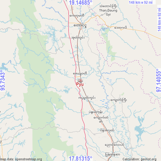
Pyu GPS coordinates[2]
18° 28' 52.68" North, 96° 26' 14.712" East
| Map corner | latitude | longitude |
|---|---|---|
| Upper-left | 19.14685°, | 95.7343° |
| Center: | 18.4813°, | 96.43742° |
| Lower-right: | 17.81315°, | 97.14055° |
| Map W x H: | 148.3×148.3 km | = 92.1×92.1mi |
| max Lat: | 25.38327° ⇑47.3% North |
| Pyu: | 18.4813° |
| min Lat: | ⇓52.7% South 9.98238° |
| min Long | Pyu | max Long |
| 92.89835° | 96.43742° | 99.88083° |
| W 55.4%⇐ | ⇒44.6% E |
Elevation
Elevation of Pyu is 55 m = 180 ft, and this is 133.9 m = 439 ft below average elevation for this country.
| Max E: |
1768 m = 5801 ft | 40.5% |
| Avg. | 188.9 m = 620 ft | |
| Pyu | 55 m = 180 ft | |
Min E: |
5 m = 16 ft | 59.5% |
See also: Pyu elevation on elevation.city.
Geographical zone
Pyu is located in North Torrid zone (between Equator and Tropic of Cancer). Distance of this Northern Tropic circle is 551 km =342.4 mi to North.| Distance of | km | miles | from Pyu |
|---|---|---|---|
| North Pole | 7952.1 | 4941.2 | to North |
| Arctic Circle | 5346.2 | 3322 | to North |
| Tropic Cancer | 551 | 342.4 | to North |
| Equator | 2054.9 | 1276.9 | to South |


Nearby cities:
15 places around Pyu: (largest is in red/bold)
• Bago
127.5 km =79.2 mi,  177°
177°
• Hinthada
138.9 km =86.3 mi,  228°
228°
• Kyaikto
143.8 km =89.4 mi,  155°
155°
• Letpandan
106 km =65.9 mi,  223°
223°
• Loikaw
155.9 km =96.9 mi,  31°
31°
• Myanaung
119.9 km =74.5 mi,  259°
259°
• Nay Pyi Taw
144.2 km =89.6 mi,  347°
347°
• Nyaunglebin
65.9 km =40.9 mi,  152°
152°
• Paungde
98.2 km =61 mi,  270°
270°
• Pyay
133.6 km =83 mi,  286°
286°
• Pyinmana
141.8 km =88.1 mi, 350°
• Taungoo
51.3 km =31.9 mi,  359°
359°
• Thanatpin
133.1 km =82.7 mi,  173°
173°
• Tharyarwady
114.8 km =71.3 mi, 216°
• Thayetmyo
161.7 km =100.5 mi,  305°
305°
Sources, notices
• [Note1] Compared only with cities in Myanmar existing in our database
• [Src1] Map data: © OpenStreetMap contributors (CC-BY-SA)
• [Src2] Other city data from geonames.org with taken over terms of usage.
• [Src3] Geographical zone / Annual Mean Temperature by Robert A. Rohde @ Wikipedia
