Pyin Oo Lwin geodata
Pyin Oo Lwin (Mandalay) is a populated place; located in Myanmar in Asia/Yangon (GMT+6.5) time zone. With population of 117,303 people, there are 19 cities with bigger population in this country. Compared to other cities in Myanmar, 87.8% of cities are located further ↓South; 56.8% of cities are located further ←West and 94.6% of cities have lower elevation than Pyin Oo Lwin. Note1


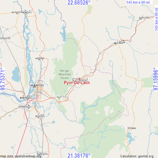
Pyin Oo Lwin GPS coordinates[2]
22° 2' 6.036" North, 96° 27' 24.588" East
| Map corner | latitude | longitude |
|---|---|---|
| Upper-left | 22.68526°, | 95.75371° |
| Center: | 22.03501°, | 96.45683° |
| Lower-right: | 21.38176°, | 97.15996° |
| Map W x H: | 144.9×144.9 km | = 90×90mi |
| max Lat: | 25.38327° ⇑12.2% North |
| Pyin Oo Lwin: | 22.03501° |
| min Lat: | ⇓87.8% South 9.98238° |
| min Long | Pyin Oo Lwin | max Long |
| 92.89835° | 96.45683° | 99.88083° |
| W 56.8%⇐ | ⇒43.2% E |
Elevation
Elevation of Pyin Oo Lwin is 1088 m = 3570 ft, and this is 899.1 m = 2950 ft above average elevation for this country.
| Max E: |
1768 m = 5801 ft | 5.4% |
| Pyin Oo Lwin | 1088 m 3570 ft | |
| Avg. | 188.9 m = 620 ft | |
Min E: |
5 m = 16 ft | 94.6% |
See also: Pyin Oo Lwin elevation on elevation.city.
Geographical zone
Pyin Oo Lwin is located in North Torrid zone (between Equator and Tropic of Cancer). Distance of this Northern Tropic circle is 155.9 km =96.9 mi to North.| Distance of | km | miles | from Pyin Oo Lwin |
|---|---|---|---|
| North Pole | 7557 | 4695.7 | to North |
| Arctic Circle | 4951.1 | 3076.5 | to North |
| Tropic Cancer | 155.9 | 96.9 | to North |
| Equator | 2450.1 | 1522.4 | to South |


Nearby cities:
15 places around Pyin Oo Lwin: (largest is in red/bold)
• Chauk
211.4 km =131.4 mi,  233°
233°
• Indein
179.5 km =111.5 mi,  167°
167°
• Kyaukse
58.2 km =36.2 mi,  214°
214°
• Lashio
166.4 km =103.4 mi,  52°
52°
• Mandalay
39.1 km =24.3 mi,  260°
260°
• Meiktila
142.8 km =88.7 mi, 205°
• Mogok
98.3 km =61.1 mi,  3°
3°
• Monywa
136.4 km =84.8 mi,  273°
273°
• Myingyan
127.5 km =79.2 mi,  239°
239°
• Nyaungshwe
160.6 km =99.8 mi,  162°
162°
• Pakokku
161.8 km =100.5 mi, 241°
• Sagaing
52.2 km =32.4 mi,  250°
250°
• Shwebo
98.1 km =61 mi,  307°
307°
• Taunggyi
151 km =93.8 mi, 156°
• Yamethin
181.3 km =112.7 mi,  190°
190°
Sources, notices
• [Note1] Compared only with cities in Myanmar existing in our database
• [Src1] Map data: © OpenStreetMap contributors (CC-BY-SA)
• [Src2] Other city data from geonames.org with taken over terms of usage.
• [Src3] Geographical zone / Annual Mean Temperature by Robert A. Rohde @ Wikipedia
