Lashio geodata
Lashio (Shan) is a populated place; located in Myanmar in Asia/Yangon (GMT+6.5) time zone. With population of 131,016 people, there are 16 cities with bigger population in this country. Compared to other cities in Myanmar, 95.9% of cities are located further ↓South; 83.8% of cities are located further ←West and 89.2% of cities have lower elevation than Lashio. Note1


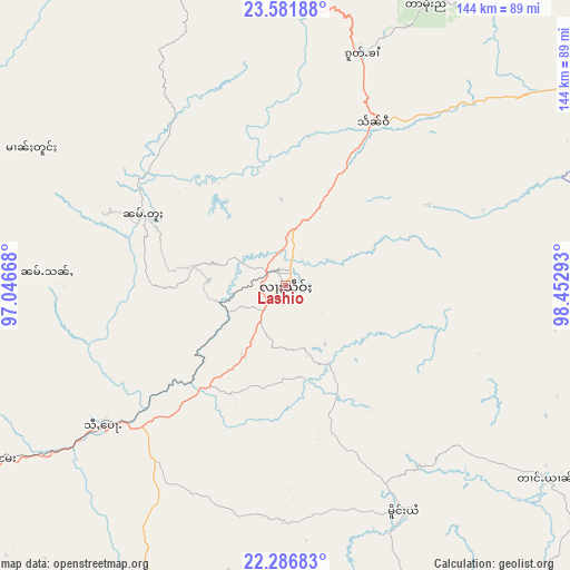
Lashio GPS coordinates[2]
22° 56' 9.24" North, 97° 44' 59.28" East
| Map corner | latitude | longitude |
|---|---|---|
| Upper-left | 23.58188°, | 97.04668° |
| Center: | 22.9359°, | 97.7498° |
| Lower-right: | 22.28683°, | 98.45293° |
| Map W x H: | 144×144 km | = 89.5×89.5mi |
| max Lat: | 25.38327° ⇑4.1% North |
| Lashio: | 22.9359° |
| min Lat: | ⇓95.9% South 9.98238° |
| min Long | Lashio | max Long |
| 92.89835° | 97.7498° | 99.88083° |
| W 83.8%⇐ | ⇒16.2% E |
Elevation
Elevation of Lashio is 845 m = 2772 ft, and this is 656.1 m = 2153 ft above average elevation for this country.
| Max E: |
1768 m = 5801 ft | 10.8% |
| Lashio | 845 m 2772 ft | |
| Avg. | 188.9 m = 620 ft | |
Min E: |
5 m = 16 ft | 89.2% |
See also: Lashio elevation on elevation.city.
Geographical zone
Lashio is located in North Torrid zone (between Equator and Tropic of Cancer). Distance of this Northern Tropic circle is 55.7 km =34.6 mi to North.| Distance of | km | miles | from Lashio |
|---|---|---|---|
| North Pole | 7456.8 | 4633.4 | to North |
| Arctic Circle | 4850.9 | 3014.2 | to North |
| Tropic Cancer | 55.7 | 34.6 | to North |
| Equator | 2550.2 | 1584.6 | to South |


Nearby cities:
15 places around Lashio: (largest is in red/bold)
• Bhamo
155.6 km =96.7 mi,  340°
340°
• Indein
290.7 km =180.6 mi,  198°
198°
• Kyaukse
222.4 km =138.2 mi,  228°
228°
• Mandalay
201.8 km =125.4 mi,  238°
238°
• Meiktila
300.7 km =186.8 mi,  220°
220°
• Mogok
127 km =78.9 mi,  269°
269°
• Monywa
283.8 km =176.3 mi,  251°
251°
• Myingyan
293.3 km =182.2 mi, 235°
• Myitkyina
274.5 km =170.6 mi,  352°
352°
• Nyaungshwe
266.6 km =165.7 mi, 198°
• Pyin Oo Lwin
166.4 km =103.4 mi, 232°
• Sagaing
216.6 km =134.6 mi, 237°
• Shwebo
214.3 km =133.2 mi,  259°
259°
• Taunggyi
249.7 km =155.2 mi, 197°
• Yamethin
324.4 km =201.6 mi,  210°
210°
Sources, notices
• [Note1] Compared only with cities in Myanmar existing in our database
• [Src1] Map data: © OpenStreetMap contributors (CC-BY-SA)
• [Src2] Other city data from geonames.org with taken over terms of usage.
• [Src3] Geographical zone / Annual Mean Temperature by Robert A. Rohde @ Wikipedia
