Taungoo geodata
Taungoo (Bago) is a populated place; located in Myanmar in Asia/Yangon (GMT+6.5) time zone. With population of 106,945 people, there are 21 cities with bigger population in this country. Compared to other cities in Myanmar, 56.8% of cities are located further ↓South; 54.1% of cities are located further ←West and 60.8% of cities have lower elevation than Taungoo. Note1


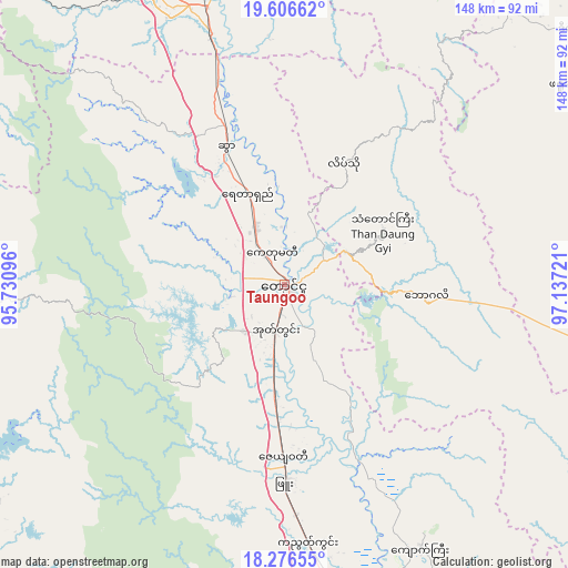
Taungoo GPS coordinates[2]
18° 56' 34.476" North, 96° 26' 2.688" East
| Map corner | latitude | longitude |
|---|---|---|
| Upper-left | 19.60662°, | 95.73096° |
| Center: | 18.94291°, | 96.43408° |
| Lower-right: | 18.27655°, | 97.13721° |
| Map W x H: | 147.9×147.9 km | = 91.9×91.9mi |
| max Lat: | 25.38327° ⇑43.2% North |
| Taungoo: | 18.94291° |
| min Lat: | ⇓56.8% South 9.98238° |
| min Long | Taungoo | max Long |
| 92.89835° | 96.43408° | 99.88083° |
| W 54.1%⇐ | ⇒45.9% E |
Elevation
Elevation of Taungoo is 56 m = 184 ft, and this is 132.9 m = 436 ft below average elevation for this country.
| Max E: |
1768 m = 5801 ft | 39.2% |
| Avg. | 188.9 m = 620 ft | |
| Taungoo | 56 m = 184 ft | |
Min E: |
5 m = 16 ft | 60.8% |
See also: Taungoo elevation on elevation.city.
Geographical zone
Taungoo is located in North Torrid zone (between Equator and Tropic of Cancer). Distance of this Northern Tropic circle is 499.7 km =310.5 mi to North.| Distance of | km | miles | from Taungoo |
|---|---|---|---|
| North Pole | 7900.8 | 4909.3 | to North |
| Arctic Circle | 5294.9 | 3290.1 | to North |
| Tropic Cancer | 499.7 | 310.5 | to North |
| Equator | 2106.3 | 1308.8 | to South |


Nearby cities:
15 places around Taungoo: (largest is in red/bold)
• Indein
174.1 km =108.2 mi,  14°
14°
• Letpandan
147.4 km =91.6 mi,  209°
209°
• Loikaw
115.3 km =71.6 mi,  44°
44°
• Myanaung
138.2 km =85.9 mi,  238°
238°
• Myaydo
136.5 km =84.8 mi,  290°
290°
• Nay Pyi Taw
94.7 km =58.8 mi,  340°
340°
• Nyaunglebin
114.1 km =70.9 mi,  164°
164°
• Paungde
109.9 km =68.3 mi, 242°
• Pyay
128.2 km =79.7 mi,  264°
264°
• Pyinmana
91.6 km =56.9 mi, 344°
• Pyu
51.3 km =31.9 mi,  179°
179°
• Taungdwingyi
150.6 km =93.6 mi,  321°
321°
• Tharyarwady
158.7 km =98.6 mi, 205°
• Thayetmyo
138 km =85.7 mi, 287°
• Yamethin
168.4 km =104.6 mi,  349°
349°
Sources, notices
• [Note1] Compared only with cities in Myanmar existing in our database
• [Src1] Map data: © OpenStreetMap contributors (CC-BY-SA)
• [Src2] Other city data from geonames.org with taken over terms of usage.
• [Src3] Geographical zone / Annual Mean Temperature by Robert A. Rohde @ Wikipedia
