Teshig geodata
Teshig (Bulgan) is a seat of a second-order administrative division; located in Mongolia in Asia/Ulaanbaatar (GMT+8) time zone. In our database, there are 33 cities with bigger population. Compared to other cities in Mongolia, 93.9% of cities are located further ↓South; 50.3% of cities are located further ←West and 83.1% of cities have higher elevation than Teshig. Note1


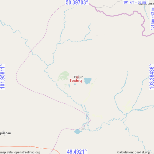
Teshig GPS coordinates[2]
49° 56' 48.084" North, 102° 39' 40.428" East
| Map corner | latitude | longitude |
|---|---|---|
| Upper-left | 50.39703°, | 101.95811° |
| Center: | 49.94669°, | 102.66123° |
| Lower-right: | 49.4921°, | 103.36436° |
| Map W x H: | 100.6×100.6 km | = 62.5×62.5mi |
| max Lat: | 51.50725° ⇑6.1% North |
| Teshig: | 49.94669° |
| min Lat: | ⇓93.9% South 42.84199° |
| min Long | Teshig | max Long |
| 89.14358° | 102.66123° | 118.51014° |
| W 50.3%⇐ | ⇒49.7% E |
Elevation
Elevation of Teshig is 1018 m = 3340 ft, and this is 398.5 m = 1307 ft below average elevation for this country.
| Max E: |
2800 m = 9186 ft | 83.1% |
| Avg. | 1416.5 m = 4647 ft | |
| Teshig | 1018 m = 3340 ft | |
Min E: |
619 m = 2031 ft | 16.9% |
See also: Mongolia elevation on elevation.city.
Geographical zone
Teshig is located in North temperate zone (between Tropic of Cancer and the Arctic Circle). Distance of this North polar circle is 1847.6 km =1148 mi to North.| Distance of | km | miles | from Teshig |
|---|---|---|---|
| North Pole | 4453.5 | 2767.3 | to North |
| Arctic Circle | 1847.6 | 1148 | to North |
| Tropic Cancer | 2947.6 | 1831.6 | to South |
| Equator | 5553.6 | 3450.8 | to South |


Nearby cities:
15 places around Teshig: (largest is in red/bold)
• Badrah
60.5 km =37.6 mi,  232°
232°
• Bugat
121.8 km =75.7 mi,  143°
143°
• Bulgan
105 km =65.2 mi,  309°
309°
• Bulgan
141.1 km =87.7 mi,  153°
153°
• Eg-Uur
79.7 km =49.5 mi,  283°
283°
• Erdenet
144.4 km =89.7 mi,  134°
134°
• Hutag
61.4 km =38.2 mi,  177°
177°
• Hüremt
142.8 km =88.7 mi, 181°
• Ingettolgoy
108.7 km =67.5 mi,  119°
119°
• Rashaant
127.4 km =79.2 mi,  224°
224°
• Selenge
103.2 km =64.1 mi,  236°
236°
• Sharga
108.8 km =67.6 mi,  202°
202°
• Sört
142.3 km =88.4 mi, 119°
• Tsengel
137.6 km =85.5 mi,  247°
247°
• Undur Sume
136.5 km =84.8 mi,  295°
295°
Sources, notices
• [Note1] Compared only with cities in Mongolia existing in our database
• [Src1] Map data: © OpenStreetMap contributors (CC-BY-SA)
• [Src2] Other city data from geonames.org with taken over terms of usage.
• [Src3] Geographical zone / Annual Mean Temperature by Robert A. Rohde @ Wikipedia
