Bugat geodata
Bugat (Bulgan) is a seat of a second-order administrative division; located in Mongolia in Asia/Ulaanbaatar (GMT+8) time zone. In our database, there are 33 cities with bigger population. Compared to other cities in Mongolia, 78.8% of cities are located further ↓South; 55.8% of cities are located further ←West and 63.2% of cities have higher elevation than Bugat. Note1


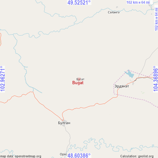
Bugat GPS coordinates[2]
49° 4' 0.012" North, 103° 39' 56.988" East
| Map corner | latitude | longitude |
|---|---|---|
| Upper-left | 49.52521°, | 102.96271° |
| Center: | 49.06667°, | 103.66583° |
| Lower-right: | 48.60386°, | 104.36896° |
| Map W x H: | 102.4×102.4 km | = 63.6×63.6mi |
| max Lat: | 51.50725° ⇑21.2% North |
| Bugat: | 49.06667° |
| min Lat: | ⇓78.8% South 42.84199° |
| min Long | Bugat | max Long |
| 89.14358° | 103.66583° | 118.51014° |
| W 55.8%⇐ | ⇒44.2% E |
Elevation
Elevation of Bugat is 1249 m = 4098 ft, and this is 167.5 m = 550 ft below average elevation for this country.
| Max E: |
2800 m = 9186 ft | 63.2% |
| Avg. | 1416.5 m = 4647 ft | |
| Bugat | 1249 m = 4098 ft | |
Min E: |
619 m = 2031 ft | 36.8% |
See also: Mongolia elevation on elevation.city.
Geographical zone
Bugat is located in North temperate zone (between Tropic of Cancer and the Arctic Circle). Distance of this North polar circle is 1945.5 km =1208.9 mi to North.| Distance of | km | miles | from Bugat |
|---|---|---|---|
| North Pole | 4551.4 | 2828.1 | to North |
| Arctic Circle | 1945.5 | 1208.9 | to North |
| Tropic Cancer | 2849.8 | 1770.8 | to South |
| Equator | 5455.7 | 3390 | to South |


Nearby cities:
15 places around Bugat: (largest is in red/bold)
• Bulgan
29.8 km =18.5 mi,  198°
198°
• Burgaltay
81.4 km =50.6 mi,  74°
74°
• Darhan
91.7 km =57 mi,  170°
170°
• Erdenet
30.6 km =19 mi,  96°
96°
• Erhet
101.5 km =63.1 mi,  209°
209°
• Hutag
79.5 km =49.4 mi,  297°
297°
• Hüremt
88.5 km =55 mi,  239°
239°
• Ingettolgoy
49.3 km =30.6 mi,  26°
26°
• Jargalant
54.5 km =33.9 mi,  82°
82°
• Maanĭt
87.4 km =54.3 mi,  191°
191°
• Mandal
49.5 km =30.8 mi, 191°
• Orhontuul
96.4 km =59.9 mi, 97°
• Sharga
114.9 km =71.4 mi,  268°
268°
• Sört
59 km =36.7 mi,  61°
61°
• Teshig
121.8 km =75.7 mi,  323°
323°
Sources, notices
• [Note1] Compared only with cities in Mongolia existing in our database
• [Src1] Map data: © OpenStreetMap contributors (CC-BY-SA)
• [Src2] Other city data from geonames.org with taken over terms of usage.
• [Src3] Geographical zone / Annual Mean Temperature by Robert A. Rohde @ Wikipedia
