Bulgan geodata
Bulgan is a seat of a first-order administrative division; located in Mongolia in Asia/Ulaanbaatar (GMT+8) time zone. With population of 17,348 people, there are 15 cities with bigger population in this country. Compared to other cities in Mongolia, 73.3% of cities are located further ↓South; 55.2% of cities are located further ←West and 67.8% of cities have higher elevation than Bulgan. Note1


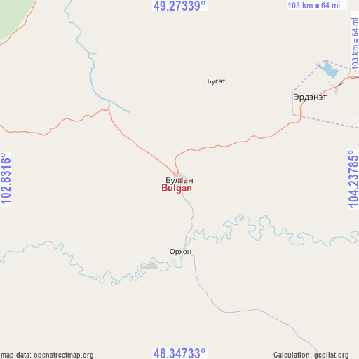
Bulgan GPS coordinates[2]
48° 48' 45" North, 103° 32' 4.992" East
| Map corner | latitude | longitude |
|---|---|---|
| Upper-left | 49.27339°, | 102.8316° |
| Center: | 48.8125°, | 103.53472° |
| Lower-right: | 48.34733°, | 104.23785° |
| Map W x H: | 103×103 km | = 64×64mi |
| max Lat: | 51.50725° ⇑26.7% North |
| Bulgan: | 48.8125° |
| min Lat: | ⇓73.3% South 42.84199° |
| min Long | Bulgan | max Long |
| 89.14358° | 103.53472° | 118.51014° |
| W 55.2%⇐ | ⇒44.8% E |
Elevation
Elevation of Bulgan is 1204 m = 3950 ft, and this is 212.5 m = 697 ft below average elevation for this country.
| Max E: |
2800 m = 9186 ft | 67.8% |
| Avg. | 1416.5 m = 4647 ft | |
| Bulgan | 1204 m = 3950 ft | |
Min E: |
619 m = 2031 ft | 32.2% |
See also: Mongolia elevation on elevation.city.
Geographical zone
Bulgan is located in North temperate zone (between Tropic of Cancer and the Arctic Circle). Distance of this North polar circle is 1973.7 km =1226.4 mi to North.| Distance of | km | miles | from Bulgan |
|---|---|---|---|
| North Pole | 4579.6 | 2845.6 | to North |
| Arctic Circle | 1973.7 | 1226.4 | to North |
| Tropic Cancer | 2821.5 | 1753.2 | to South |
| Equator | 5427.4 | 3372.4 | to South |


Nearby cities:
15 places around Bulgan: (largest is in red/bold)
• Bugat
29.8 km =18.5 mi,  18°
18°
• Burgaltay
101.5 km =63.1 mi,  60°
60°
• Darhan
67.1 km =41.7 mi,  157°
157°
• Erdenet
47 km =29.2 mi, 58°
• Erhet
72.4 km =45 mi,  214°
214°
• Hutag
89.1 km =55.4 mi,  316°
316°
• Höshööt
107 km =66.5 mi,  222°
222°
• Hüremt
68.9 km =42.8 mi,  256°
256°
• Ingettolgoy
78.9 km =49 mi, 23°
• Jargalant
72.8 km =45.2 mi, 61°
• Maanĭt
57.9 km =36 mi,  187°
187°
• Mandal
20.2 km =12.6 mi,  181°
181°
• Orhontuul
106.5 km =66.2 mi,  81°
81°
• Sharga
108.6 km =67.5 mi,  283°
283°
• Sört
83.4 km =51.8 mi,  47°
47°
Sources, notices
• [Note1] Compared only with cities in Mongolia existing in our database
• [Src1] Map data: © OpenStreetMap contributors (CC-BY-SA)
• [Src2] Other city data from geonames.org with taken over terms of usage.
• [Src3] Geographical zone / Annual Mean Temperature by Robert A. Rohde @ Wikipedia
