Nomgon geodata
Nomgon (Selenge) is a seat of a second-order administrative division; located in Mongolia in Asia/Ulaanbaatar (GMT+8) time zone. In our database, there are 33 cities with bigger population. Compared to other cities in Mongolia, 81% of cities are located further ↓South; 67.5% of cities are located further ←West and 90.2% of cities have higher elevation than Nomgon. Note1


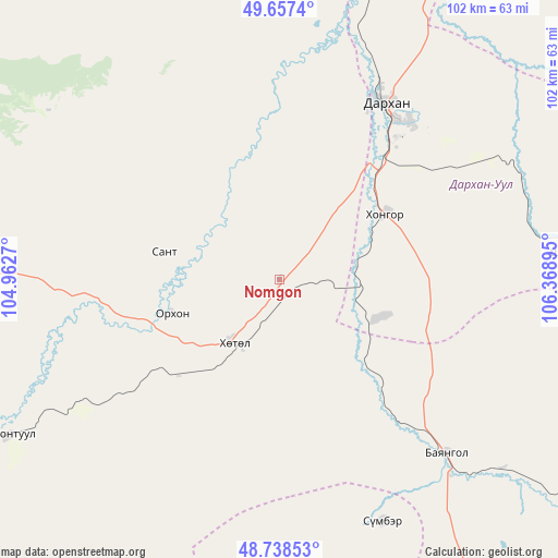
Nomgon GPS coordinates[2]
49° 12' 0.36" North, 105° 39' 56.952" East
| Map corner | latitude | longitude |
|---|---|---|
| Upper-left | 49.6574°, | 104.9627° |
| Center: | 49.2001°, | 105.66582° |
| Lower-right: | 48.73853°, | 106.36895° |
| Map W x H: | 102.2×102.2 km | = 63.5×63.5mi |
| max Lat: | 51.50725° ⇑19% North |
| Nomgon: | 49.2001° |
| min Lat: | ⇓81% South 42.84199° |
| min Long | Nomgon | max Long |
| 89.14358° | 105.66582° | 118.51014° |
| W 67.5%⇐ | ⇒32.5% E |
Elevation
Elevation of Nomgon is 879 m = 2884 ft, and this is 537.5 m = 1763 ft below average elevation for this country.
| Max E: |
2800 m = 9186 ft | 90.2% |
| Avg. | 1416.5 m = 4647 ft | |
| Nomgon | 879 m = 2884 ft | |
Min E: |
619 m = 2031 ft | 9.8% |
See also: Mongolia elevation on elevation.city.
Geographical zone
Nomgon is located in North temperate zone (between Tropic of Cancer and the Arctic Circle). Distance of this North polar circle is 1930.6 km =1199.6 mi to North.| Distance of | km | miles | from Nomgon |
|---|---|---|---|
| North Pole | 4536.5 | 2818.8 | to North |
| Arctic Circle | 1930.6 | 1199.6 | to North |
| Tropic Cancer | 2864.6 | 1780 | to South |
| Equator | 5470.5 | 3399.2 | to South |


Nearby cities:
15 places around Nomgon: (largest is in red/bold)
• Bornuur
92.7 km =57.6 mi,  151°
151°
• Burgaltay
67.4 km =41.9 mi,  276°
276°
• Darhan
36.9 km =22.9 mi,  30°
30°
• Dzüünharaa
69.5 km =43.2 mi,  123°
123°
• Enhtal
21.9 km =13.6 mi, 283°
• Hongor
17.1 km =10.6 mi,  78°
78°
• Hushaat
33.5 km =20.8 mi,  353°
353°
• Jargalant
77 km =47.8 mi,  168°
168°
• Jargalant
91.8 km =57 mi,  265°
265°
• Javhlant
48.1 km =29.9 mi,  156°
156°
• Nart
21.1 km =13.1 mi,  253°
253°
• Orgil
86.8 km =53.9 mi,  197°
197°
• Orhon
78.1 km =48.5 mi, 25°
• Orhontuul
57.5 km =35.7 mi,  241°
241°
• Sharïngol
55.7 km =34.6 mi,  85°
85°
Sources, notices
• [Note1] Compared only with cities in Mongolia existing in our database
• [Src1] Map data: © OpenStreetMap contributors (CC-BY-SA)
• [Src2] Other city data from geonames.org with taken over terms of usage.
• [Src3] Geographical zone / Annual Mean Temperature by Robert A. Rohde @ Wikipedia
