Nart geodata
Nart (Selenge) is a seat of a second-order administrative division; located in Mongolia in Asia/Ulaanbaatar (GMT+8) time zone. In our database, there are 33 cities with bigger population. Compared to other cities in Mongolia, 80.4% of cities are located further ↓South; 65.6% of cities are located further ←West and 96.6% of cities have higher elevation than Nart. Note1


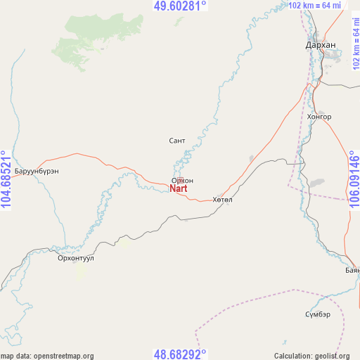
Nart GPS coordinates[2]
49° 8' 42" North, 105° 23' 17.988" East
| Map corner | latitude | longitude |
|---|---|---|
| Upper-left | 49.60281°, | 104.68521° |
| Center: | 49.145°, | 105.38833° |
| Lower-right: | 48.68292°, | 106.09146° |
| Map W x H: | 102.3×102.3 km | = 63.6×63.6mi |
| max Lat: | 51.50725° ⇑19.6% North |
| Nart: | 49.145° |
| min Lat: | ⇓80.4% South 42.84199° |
| min Long | Nart | max Long |
| 89.14358° | 105.38833° | 118.51014° |
| W 65.6%⇐ | ⇒34.4% E |
Elevation
Elevation of Nart is 735 m = 2411 ft, and this is 681.5 m = 2236 ft below average elevation for this country.
| Max E: |
2800 m = 9186 ft | 96.6% |
| Avg. | 1416.5 m = 4647 ft | |
| Nart | 735 m = 2411 ft | |
Min E: |
619 m = 2031 ft | 3.4% |
See also: Mongolia elevation on elevation.city.
Geographical zone
Nart is located in North temperate zone (between Tropic of Cancer and the Arctic Circle). Distance of this North polar circle is 1936.8 km =1203.5 mi to North.| Distance of | km | miles | from Nart |
|---|---|---|---|
| North Pole | 4542.7 | 2822.7 | to North |
| Arctic Circle | 1936.8 | 1203.5 | to North |
| Tropic Cancer | 2858.5 | 1776.2 | to South |
| Equator | 5464.4 | 3395.4 | to South |


Nearby cities:
15 places around Nart: (largest is in red/bold)
• Burgaltay
48.7 km =30.3 mi,  285°
285°
• Darhan
54.3 km =33.7 mi,  45°
45°
• Dzüünharaa
84.5 km =52.5 mi,  112°
112°
• Enhtal
11.4 km =7.1 mi,  354°
354°
• Hongor
38.1 km =23.7 mi,  75°
75°
• Hushaat
42.8 km =26.6 mi,  22°
22°
• Jargalant
71.3 km =44.3 mi,  268°
268°
• Jargalant
77.8 km =48.3 mi,  153°
153°
• Javhlant
54.6 km =33.9 mi,  134°
134°
• Nomgon
21.1 km =13.1 mi,  73°
73°
• Orgil
77 km =47.8 mi,  183°
183°
• Orhon
93.6 km =58.2 mi,  35°
35°
• Orhontuul
37.1 km =23.1 mi,  234°
234°
• Sharïngol
76.4 km =47.5 mi, 82°
• Sört
75.5 km =46.9 mi,  284°
284°
Sources, notices
• [Note1] Compared only with cities in Mongolia existing in our database
• [Src1] Map data: © OpenStreetMap contributors (CC-BY-SA)
• [Src2] Other city data from geonames.org with taken over terms of usage.
• [Src3] Geographical zone / Annual Mean Temperature by Robert A. Rohde @ Wikipedia
