Darhan geodata
Darhan (Darhan Uul) is a seat of a first-order administrative division; located in Mongolia in Asia/Ulaanbaatar (GMT+8) time zone. With population of 74,300 people, there are 2 cities with bigger population in this country. Compared to other cities in Mongolia, 86.8% of cities are located further ↓South; 70.2% of cities are located further ←West and 98.5% of cities have higher elevation than Darhan. Note1


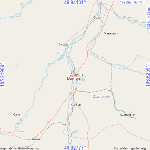
Darhan GPS coordinates[2]
49° 29' 12.012" North, 105° 55' 22.008" East
| Map corner | latitude | longitude |
|---|---|---|
| Upper-left | 49.94131°, | 105.21966° |
| Center: | 49.48667°, | 105.92278° |
| Lower-right: | 49.02777°, | 106.62591° |
| Map W x H: | 101.6×101.6 km | = 63.1×63.1mi |
| max Lat: | 51.50725° ⇑13.2% North |
| Darhan: | 49.48667° |
| min Lat: | ⇓86.8% South 42.84199° |
| min Long | Darhan | max Long |
| 89.14358° | 105.92278° | 118.51014° |
| W 70.2%⇐ | ⇒29.8% E |
Elevation
Elevation of Darhan is 683 m = 2241 ft, and this is 733.5 m = 2406 ft below average elevation for this country.
| Max E: |
2800 m = 9186 ft | 98.5% |
| Avg. | 1416.5 m = 4647 ft | |
| Darhan | 683 m = 2241 ft | |
Min E: |
619 m = 2031 ft | 1.5% |
See also: Darhan elevation on elevation.city.
Geographical zone
Darhan is located in North temperate zone (between Tropic of Cancer and the Arctic Circle). Distance of this North polar circle is 1898.8 km =1179.9 mi to North.| Distance of | km | miles | from Darhan |
|---|---|---|---|
| North Pole | 4504.7 | 2799.1 | to North |
| Arctic Circle | 1898.8 | 1179.9 | to North |
| Tropic Cancer | 2896.5 | 1799.8 | to South |
| Equator | 5502.4 | 3419 | to South |


Nearby cities:
15 places around Darhan: (largest is in red/bold)
• Bugant
67.8 km =42.1 mi,  80°
80°
• Burgaltay
88.9 km =55.2 mi,  253°
253°
• Delgerhaan
69.2 km =43 mi,  15°
15°
• Dzüünharaa
80.6 km =50.1 mi,  151°
151°
• Enhtal
47.8 km =29.7 mi,  236°
236°
• Hongor
28.6 km =17.8 mi,  183°
183°
• Hushaat
22.2 km =13.8 mi,  273°
273°
• Huurch
77.5 km =48.2 mi,  332°
332°
• Jargalant
64.7 km =40.2 mi,  357°
357°
• Javhlant
76.1 km =47.3 mi, 179°
• Nart
54.3 km =33.7 mi,  225°
225°
• Nomgon
36.9 km =22.9 mi,  210°
210°
• Orhon
41.4 km =25.7 mi, 21°
• Sharïngol
46 km =28.6 mi,  127°
127°
• Sühbaatar
85.3 km =53 mi,  13°
13°
Sources, notices
• [Note1] Compared only with cities in Mongolia existing in our database
• [Src1] Map data: © OpenStreetMap contributors (CC-BY-SA)
• [Src2] Other city data from geonames.org with taken over terms of usage.
• [Src3] Geographical zone / Annual Mean Temperature by Robert A. Rohde @ Wikipedia
