Hongor geodata
Hongor (Darhan Uul) is a seat of a second-order administrative division; located in Mongolia in Asia/Ulaanbaatar (GMT+8) time zone. In our database, there are 33 cities with bigger population. Compared to other cities in Mongolia, 81.3% of cities are located further ↓South; 69.6% of cities are located further ←West and 95.4% of cities have higher elevation than Hongor. Note1


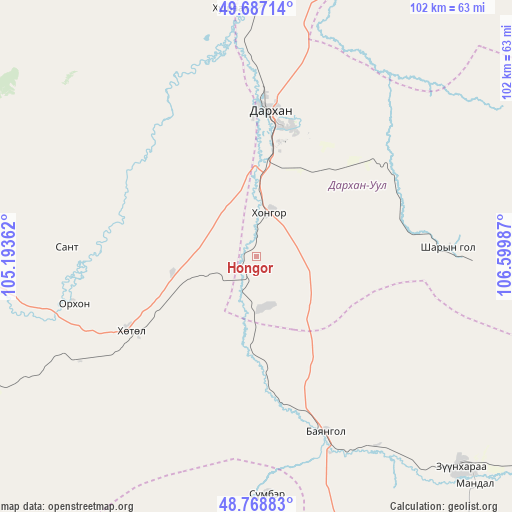
Hongor GPS coordinates[2]
49° 13' 48.432" North, 105° 53' 48.264" East
| Map corner | latitude | longitude |
|---|---|---|
| Upper-left | 49.68714°, | 105.19362° |
| Center: | 49.23012°, | 105.89674° |
| Lower-right: | 48.76883°, | 106.59987° |
| Map W x H: | 102.1×102.1 km | = 63.4×63.4mi |
| max Lat: | 51.50725° ⇑18.7% North |
| Hongor: | 49.23012° |
| min Lat: | ⇓81.3% South 42.84199° |
| min Long | Hongor | max Long |
| 89.14358° | 105.89674° | 118.51014° |
| W 69.6%⇐ | ⇒30.4% E |
Elevation
Elevation of Hongor is 747 m = 2451 ft, and this is 669.5 m = 2197 ft below average elevation for this country.
| Max E: |
2800 m = 9186 ft | 95.4% |
| Avg. | 1416.5 m = 4647 ft | |
| Hongor | 747 m = 2451 ft | |
Min E: |
619 m = 2031 ft | 4.6% |
See also: Mongolia elevation on elevation.city.
Geographical zone
Hongor is located in North temperate zone (between Tropic of Cancer and the Arctic Circle). Distance of this North polar circle is 1927.3 km =1197.6 mi to North.| Distance of | km | miles | from Hongor |
|---|---|---|---|
| North Pole | 4533.2 | 2816.8 | to North |
| Arctic Circle | 1927.3 | 1197.6 | to North |
| Tropic Cancer | 2868 | 1782.1 | to South |
| Equator | 5473.9 | 3401.3 | to South |


Nearby cities:
15 places around Hongor: (largest is in red/bold)
• Bornuur
89.1 km =55.4 mi,  162°
162°
• Bugant
79.4 km =49.3 mi,  60°
60°
• Burgaltay
83.8 km =52.1 mi,  272°
272°
• Darhan
28.6 km =17.8 mi,  3°
3°
• Dzüünharaa
58.6 km =36.4 mi,  135°
135°
• Dzüünkharaa
90.2 km =56 mi, 137°
• Enhtal
38 km =23.6 mi, 272°
• Hushaat
36.2 km =22.5 mi,  325°
325°
• Jargalant
78.9 km =49 mi,  181°
181°
• Javhlant
47.7 km =29.6 mi, 177°
• Nart
38.1 km =23.7 mi,  255°
255°
• Nomgon
17.1 km =10.6 mi, 258°
• Orhon
69.2 km =43 mi,  14°
14°
• Orhontuul
73.9 km =45.9 mi,  245°
245°
• Sharïngol
38.7 km =24 mi,  88°
88°
Sources, notices
• [Note1] Compared only with cities in Mongolia existing in our database
• [Src1] Map data: © OpenStreetMap contributors (CC-BY-SA)
• [Src2] Other city data from geonames.org with taken over terms of usage.
• [Src3] Geographical zone / Annual Mean Temperature by Robert A. Rohde @ Wikipedia
