Orhontuul geodata
Orhontuul (Selenge) is a seat of a second-order administrative division; located in Mongolia in Asia/Ulaanbaatar (GMT+8) time zone. In our database, there are 33 cities with bigger population. Compared to other cities in Mongolia, 75.8% of cities are located further ↓South; 63.2% of cities are located further ←West and 94.5% of cities have higher elevation than Orhontuul. Note1


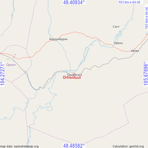
Orhontuul GPS coordinates[2]
48° 56' 58.992" North, 104° 58' 32.988" East
| Map corner | latitude | longitude |
|---|---|---|
| Upper-left | 49.40934°, | 104.27271° |
| Center: | 48.94972°, | 104.97583° |
| Lower-right: | 48.48582°, | 105.67896° |
| Map W x H: | 102.7×102.7 km | = 63.8×63.8mi |
| max Lat: | 51.50725° ⇑24.2% North |
| Orhontuul: | 48.94972° |
| min Lat: | ⇓75.8% South 42.84199° |
| min Long | Orhontuul | max Long |
| 89.14358° | 104.97583° | 118.51014° |
| W 63.2%⇐ | ⇒36.8% E |
Elevation
Elevation of Orhontuul is 763 m = 2503 ft, and this is 653.5 m = 2144 ft below average elevation for this country.
| Max E: |
2800 m = 9186 ft | 94.5% |
| Avg. | 1416.5 m = 4647 ft | |
| Orhontuul | 763 m = 2503 ft | |
Min E: |
619 m = 2031 ft | 5.5% |
See also: Mongolia elevation on elevation.city.
Geographical zone
Orhontuul is located in North temperate zone (between Tropic of Cancer and the Arctic Circle). Distance of this North polar circle is 1958.5 km =1217 mi to North.| Distance of | km | miles | from Orhontuul |
|---|---|---|---|
| North Pole | 4564.4 | 2836.2 | to North |
| Arctic Circle | 1958.5 | 1217 | to North |
| Tropic Cancer | 2836.8 | 1762.7 | to South |
| Equator | 5442.7 | 3381.9 | to South |


Nearby cities:
15 places around Orhontuul: (largest is in red/bold)
• Ar-Asgat
82.9 km =51.5 mi,  157°
157°
• Bat-Öldziyt
83 km =51.6 mi,  190°
190°
• Burgaltay
38.9 km =24.2 mi,  334°
334°
• Darhan
91.1 km =56.6 mi,  49°
49°
• Enhtal
44 km =27.3 mi,  41°
41°
• Erdenet
65.8 km =40.9 mi,  278°
278°
• Hongor
73.9 km =45.9 mi,  65°
65°
• Hushaat
76.9 km =47.8 mi, 37°
• Jargalant
45.9 km =28.5 mi,  295°
295°
• Jargalant
81 km =50.3 mi,  126°
126°
• Javhlant
71.3 km =44.3 mi,  103°
103°
• Nart
37.1 km =23.1 mi, 54°
• Nomgon
57.5 km =35.7 mi,  61°
61°
• Orgil
60.6 km =37.7 mi, 155°
• Sört
59.5 km =37 mi,  313°
313°
Sources, notices
• [Note1] Compared only with cities in Mongolia existing in our database
• [Src1] Map data: © OpenStreetMap contributors (CC-BY-SA)
• [Src2] Other city data from geonames.org with taken over terms of usage.
• [Src3] Geographical zone / Annual Mean Temperature by Robert A. Rohde @ Wikipedia
