Hushaat geodata
Hushaat (Selenge) is a seat of a second-order administrative division; located in Mongolia in Asia/Ulaanbaatar (GMT+8) time zone. In our database, there are 33 cities with bigger population. Compared to other cities in Mongolia, 87.1% of cities are located further ↓South; 67.2% of cities are located further ←West and 94.2% of cities have higher elevation than Hushaat. Note1


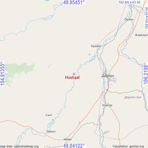
Hushaat GPS coordinates[2]
49° 30' 0" North, 105° 37' 0.012" East
| Map corner | latitude | longitude |
|---|---|---|
| Upper-left | 49.95451°, | 104.91355° |
| Center: | 49.5°, | 105.61667° |
| Lower-right: | 49.04122°, | 106.3198° |
| Map W x H: | 101.5×101.5 km | = 63.1×63.1mi |
| max Lat: | 51.50725° ⇑12.9% North |
| Hushaat: | 49.5° |
| min Lat: | ⇓87.1% South 42.84199° |
| min Long | Hushaat | max Long |
| 89.14358° | 105.61667° | 118.51014° |
| W 67.2%⇐ | ⇒32.8% E |
Elevation
Elevation of Hushaat is 765 m = 2510 ft, and this is 651.5 m = 2137 ft below average elevation for this country.
| Max E: |
2800 m = 9186 ft | 94.2% |
| Avg. | 1416.5 m = 4647 ft | |
| Hushaat | 765 m = 2510 ft | |
Min E: |
619 m = 2031 ft | 5.8% |
See also: Mongolia elevation on elevation.city.
Geographical zone
Hushaat is located in North temperate zone (between Tropic of Cancer and the Arctic Circle). Distance of this North polar circle is 1897.3 km =1178.9 mi to North.| Distance of | km | miles | from Hushaat |
|---|---|---|---|
| North Pole | 4503.2 | 2798.2 | to North |
| Arctic Circle | 1897.3 | 1178.9 | to North |
| Tropic Cancer | 2898 | 1800.7 | to South |
| Equator | 5503.9 | 3420 | to South |


Nearby cities:
15 places around Hushaat: (largest is in red/bold)
• Bugant
89.5 km =55.6 mi,  84°
84°
• Burgaltay
68.4 km =42.5 mi,  247°
247°
• Darhan
22.2 km =13.8 mi,  93°
93°
• Delgerhaan
76.9 km =47.8 mi,  32°
32°
• Enhtal
33.1 km =20.6 mi,  212°
212°
• Hongor
36.2 km =22.5 mi,  145°
145°
• Huurch
68.6 km =42.6 mi,  348°
348°
• Jargalant
65.9 km =40.9 mi,  16°
16°
• Javhlant
80.8 km =50.2 mi,  163°
163°
• Nart
42.8 km =26.6 mi,  202°
202°
• Nomgon
33.5 km =20.8 mi,  173°
173°
• Orhon
52.6 km =32.7 mi,  45°
45°
• Orhontuul
76.9 km =47.8 mi,  217°
217°
• Sharïngol
65.7 km =40.8 mi,  116°
116°
• Sört
91.6 km =56.9 mi,  257°
257°
Sources, notices
• [Note1] Compared only with cities in Mongolia existing in our database
• [Src1] Map data: © OpenStreetMap contributors (CC-BY-SA)
• [Src2] Other city data from geonames.org with taken over terms of usage.
• [Src3] Geographical zone / Annual Mean Temperature by Robert A. Rohde @ Wikipedia
