Orhon geodata
Orhon (Darhan Uul) is a seat of a second-order administrative division; located in Mongolia in Asia/Ulaanbaatar (GMT+8) time zone. In our database, there are 33 cities with bigger population. Compared to other cities in Mongolia, 92.3% of cities are located further ↓South; 71.2% of cities are located further ←West and 99.1% of cities have higher elevation than Orhon. Note1


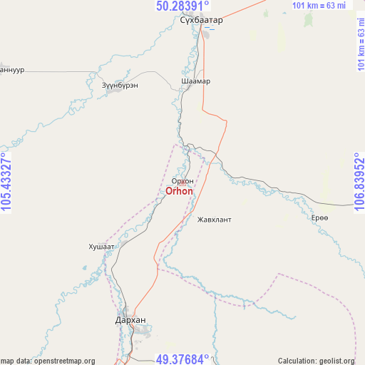
Orhon GPS coordinates[2]
49° 49' 57" North, 106° 8' 11.004" East
| Map corner | latitude | longitude |
|---|---|---|
| Upper-left | 50.28391°, | 105.43327° |
| Center: | 49.8325°, | 106.13639° |
| Lower-right: | 49.37684°, | 106.83952° |
| Map W x H: | 100.9×100.9 km | = 62.7×62.7mi |
| max Lat: | 51.50725° ⇑7.7% North |
| Orhon: | 49.8325° |
| min Lat: | ⇓92.3% South 42.84199° |
| min Long | Orhon | max Long |
| 89.14358° | 106.13639° | 118.51014° |
| W 71.2%⇐ | ⇒28.8% E |
Elevation
Elevation of Orhon is 638 m = 2093 ft, and this is 778.5 m = 2554 ft below average elevation for this country.
| Max E: |
2800 m = 9186 ft | 99.1% |
| Avg. | 1416.5 m = 4647 ft | |
| Orhon | 638 m = 2093 ft | |
Min E: |
619 m = 2031 ft | 0.9% |
See also: Mongolia elevation on elevation.city.
Geographical zone
Orhon is located in North temperate zone (between Tropic of Cancer and the Arctic Circle). Distance of this North polar circle is 1860.3 km =1155.9 mi to North.| Distance of | km | miles | from Orhon |
|---|---|---|---|
| North Pole | 4466.2 | 2775.2 | to North |
| Arctic Circle | 1860.3 | 1155.9 | to North |
| Tropic Cancer | 2934.9 | 1823.7 | to South |
| Equator | 5540.9 | 3443 | to South |


Nearby cities:
15 places around Orhon: (largest is in red/bold)
• Altanbulag
59.6 km =37 mi,  25°
25°
• Bugant
58.3 km =36.2 mi,  118°
118°
• Bulagtay
99.2 km =61.6 mi,  93°
93°
• Darhan
41.4 km =25.7 mi,  201°
201°
• Delgerhaan
28.4 km =17.6 mi,  7°
7°
• Dzelter
94.6 km =58.8 mi,  304°
304°
• Enhtal
85.2 km =52.9 mi,  220°
220°
• Hongor
69.2 km =43 mi,  194°
194°
• Hushaat
52.6 km =32.7 mi,  225°
225°
• Huurch
59.4 km =36.9 mi, 300°
• Jargalant
31.9 km =19.8 mi,  324°
324°
• Nart
93.6 km =58.2 mi, 215°
• Nomgon
78.1 km =48.5 mi,  205°
205°
• Sharïngol
69.5 km =43.2 mi,  162°
162°
• Sühbaatar
44.6 km =27.7 mi, 6°
Sources, notices
• [Note1] Compared only with cities in Mongolia existing in our database
• [Src1] Map data: © OpenStreetMap contributors (CC-BY-SA)
• [Src2] Other city data from geonames.org with taken over terms of usage.
• [Src3] Geographical zone / Annual Mean Temperature by Robert A. Rohde @ Wikipedia
