Karonga geodata
Karonga (Northern Region) is a seat of a second-order administrative division; located in Malawi in Africa/Blantyre (GMT+2) time zone. With population of 34,207 people, there are 6 cities with bigger population in this country. Compared to other cities in Malawi, 97.1% of cities are located further ↓South; 77.1% of cities are located further →East and 85.7% of cities have higher elevation than Karonga. Note1


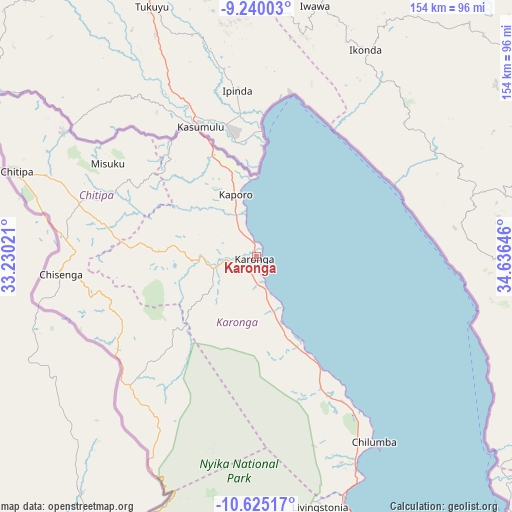
Karonga GPS coordinates[2]
9° 55' 59.988" South, 33° 55' 59.988" East
| Map corner | latitude | longitude |
|---|---|---|
| Upper-left | -9.24003°, | 33.23021° |
| Center: | -9.93333°, | 33.93333° |
| Lower-right: | -10.62517°, | 34.63646° |
| Map W x H: | 154×154 km | = 95.7×95.7mi |
| max Lat: | -9.70237° ⇑2.9% North |
| Karonga: | -9.93333° |
| min Lat: | ⇓97.1% South -16.91995° |
| min Long | Karonga | max Long |
| 32.88019° | 33.93333° | 35.65067° |
| W 22.9%⇐ | ⇒77.1% E |
Elevation
Elevation of Karonga is 486 m = 1594 ft, and this is 382.7 m = 1256 ft below average elevation for this country.
| Max E: |
1608 m = 5276 ft | 85.7% |
| Avg. | 868.7 m = 2850 ft | |
| Karonga | 486 m = 1594 ft | |
Min E: |
55 m = 180 ft | 14.3% |
See also: Malawi elevation on elevation.city.
Geographical zone
Karonga is located in South Torrid zone (between Equator and Tropic of Capricorn). Distance of Equator is 1104.5 km =686.3 mi to North.| Distance of | km | miles | from Karonga |
|---|---|---|---|
| Equator | 1104.5 | 686.3 | to North |
| Tropic Capricorn | 1501.4 | 932.9 | to South |
| Antarctic Circle | 6296.7 | 3912.6 | to South |
| South Pole | 8902.6 | 5531.8 | to South |


Nearby cities:
13 places around Karonga: (largest is in red/bold)
• Chitipa
77.1 km =47.9 mi,  289°
289°
• Dowa
413.7 km =257.1 mi,  179°
179°
• Kasungu
348.2 km =216.4 mi,  188°
188°
• Likoma
252.8 km =157.1 mi,  159°
159°
• Livingstonia
77.2 km =48 mi,  165°
165°
• Mponela
400.7 km =249 mi, 183°
• Mzimba
221.7 km =137.8 mi, 189°
• Mzuzu
170.6 km =106 mi, 176°
• Nkhata Bay
190.1 km =118.1 mi, 168°
• Nkhotakota
335.3 km =208.3 mi, 173°
• Ntchisi
399.7 km =248.4 mi, 180°
• Rumphi
121 km =75.2 mi, 183°
• Salima
431.6 km =268.2 mi, 172°
Sources, notices
• [Note1] Compared only with cities in Malawi existing in our database
• [Src1] Map data: © OpenStreetMap contributors (CC-BY-SA)
• [Src2] Other city data from geonames.org with taken over terms of usage.
• [Src3] Geographical zone / Annual Mean Temperature by Robert A. Rohde @ Wikipedia
