Mzuzu geodata
Mzuzu (Northern Region) is a seat of a first-order administrative division; located in Malawi in Africa/Blantyre (GMT+2) time zone. With population of 175,345 people, there are 2 cities with bigger population in this country. Compared to other cities in Malawi, 88.6% of cities are located further ↓South; 71.4% of cities are located further →East and 82.9% of cities have lower elevation than Mzuzu. Note1


Mzuzu GPS coordinates[2]
11° 27' 56.016" South, 34° 1' 14.556" East
| Map corner | latitude | longitude |
|---|---|---|
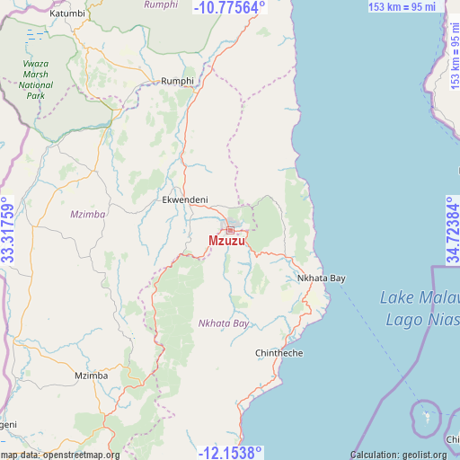
| Upper-left | -10.77564°, | 33.31759° |
| Center: | -11.46556°, | 34.02071° |
| Lower-right: | -12.1538°, | 34.72384° |
| Map W x H: | 153.2×153.2 km | = 95.2×95.2mi |
| max Lat: | -9.70237° ⇑11.4% North |
| Mzuzu: | -11.46556° |
| min Lat: | ⇓88.6% South -16.91995° |
| min Long | Mzuzu | max Long |
| 32.88019° | 34.02071° | 35.65067° |
| W 28.6%⇐ | ⇒71.4% E |
Elevation
Elevation of Mzuzu is 1275 m = 4183 ft, and this is 406.3 m = 1333 ft above average elevation for this country.
| Max E: |
1608 m = 5276 ft | 17.1% |
| Mzuzu | 1275 m 4183 ft | |
| Avg. | 868.7 m = 2850 ft | |
Min E: |
55 m = 180 ft | 82.9% |
See also: Mzuzu elevation on elevation.city.
Geographical zone
Mzuzu is located in South Torrid zone (between Equator and Tropic of Capricorn). Distance of Equator is 1274.9 km =792.2 mi to North.| Distance of | km | miles | from Mzuzu |
|---|---|---|---|
| Equator | 1274.9 | 792.2 | to North |
| Tropic Capricorn | 1331.1 | 827.1 | to South |
| Antarctic Circle | 6126.3 | 3806.7 | to South |
| South Pole | 8732.2 | 5425.9 | to South |


Nearby cities:
15 places around Mzuzu: (largest is in red/bold)
• Chipoka
286.1 km =177.8 mi,  169°
169°
• Chitipa
212.5 km =132 mi,  337°
337°
• Dowa
243.5 km =151.3 mi,  182°
182°
• Karonga
170.6 km =106 mi,  356°
356°
• Kasungu
183.8 km =114.2 mi,  198°
198°
• Likoma
102.4 km =63.6 mi,  130°
130°
• Lilongwe
279.3 km =173.5 mi,  185°
185°
• Livingstonia
96 km =59.7 mi,  5°
5°
• Mponela
231.8 km =144 mi, 187°
• Mzimba
66.6 km =41.4 mi,  223°
223°
• Nkhata Bay
33.3 km =20.7 mi,  118°
118°
• Nkhotakota
165.3 km =102.7 mi, 169°
• Ntchisi
229.6 km =142.7 mi, 182°
• Rumphi
52.8 km =32.8 mi, 340°
• Salima
261.7 km =162.6 mi, 169°
Sources, notices
• [Note1] Compared only with cities in Malawi existing in our database
• [Src1] Map data: © OpenStreetMap contributors (CC-BY-SA)
• [Src2] Other city data from geonames.org with taken over terms of usage.
• [Src3] Geographical zone / Annual Mean Temperature by Robert A. Rohde @ Wikipedia
