Likoma geodata
Likoma (Northern Region) is a seat of a second-order administrative division; located in Malawi in Africa/Blantyre (GMT+2) time zone. In our database, there are 33 cities with bigger population. Compared to other cities in Malawi, 80% of cities are located further ↓South; 57.1% of cities are located further ←West and 77.1% of cities have higher elevation than Likoma. Note1


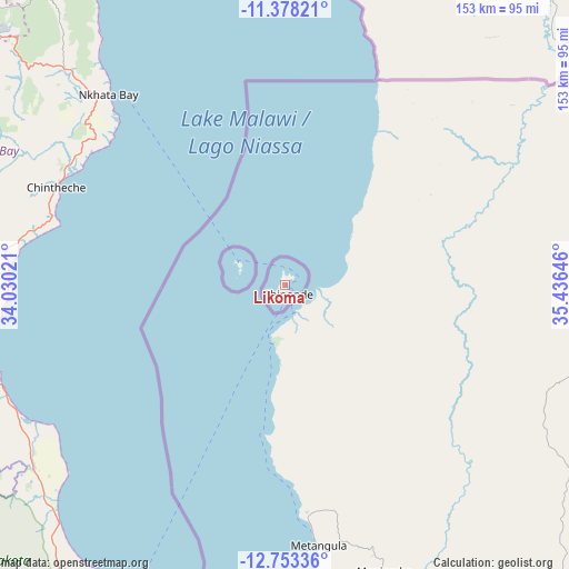
Likoma GPS coordinates[2]
12° 4' 0.012" South, 34° 43' 59.988" East
| Map corner | latitude | longitude |
|---|---|---|
| Upper-left | -11.37821°, | 34.03021° |
| Center: | -12.06667°, | 34.73333° |
| Lower-right: | -12.75336°, | 35.43646° |
| Map W x H: | 152.9×152.9 km | = 95×95mi |
| max Lat: | -9.70237° ⇑20% North |
| Likoma: | -12.06667° |
| min Lat: | ⇓80% South -16.91995° |
| min Long | Likoma | max Long |
| 32.88019° | 34.73333° | 35.65067° |
| W 57.1%⇐ | ⇒42.9% E |
Elevation
Elevation of Likoma is 506 m = 1660 ft, and this is 362.7 m = 1190 ft below average elevation for this country.
| Max E: |
1608 m = 5276 ft | 77.1% |
| Avg. | 868.7 m = 2850 ft | |
| Likoma | 506 m = 1660 ft | |
Min E: |
55 m = 180 ft | 22.9% |
See also: Malawi elevation on elevation.city.
Geographical zone
Likoma is located in South Torrid zone (between Equator and Tropic of Capricorn). Distance of this Southern Tropic circle is 1264.2 km =785.5 mi to South.| Distance of | km | miles | from Likoma |
|---|---|---|---|
| Equator | 1341.7 | 833.7 | to North |
| Tropic Capricorn | 1264.2 | 785.5 | to South |
| Antarctic Circle | 6059.5 | 3765.2 | to South |
| South Pole | 8665.4 | 5384.4 | to South |


Nearby cities:
15 places around Likoma: (largest is in red/bold)
• Chipoka
215.5 km =133.9 mi,  186°
186°
• Dowa
196.4 km =122 mi,  206°
206°
• Karonga
252.8 km =157.1 mi,  339°
339°
• Kasungu
173.1 km =107.6 mi,  231°
231°
• Lilongwe
234.8 km =145.9 mi, 205°
• Livingstonia
176.2 km =109.5 mi, 337°
• Monkey Bay
225 km =139.8 mi,  174°
174°
• Mponela
195.3 km =121.4 mi, 213°
• Mzimba
124.7 km =77.5 mi,  278°
278°
• Mzuzu
102.4 km =63.6 mi,  310°
310°
• Nkhata Bay
70.3 km =43.7 mi,  316°
316°
• Nkhotakota
106.8 km =66.4 mi, 206°
• Ntchisi
185.1 km =115 mi, 208°
• Rumphi
150.6 km =93.6 mi, 320°
• Salima
192.9 km =119.9 mi, 188°
Sources, notices
• [Note1] Compared only with cities in Malawi existing in our database
• [Src1] Map data: © OpenStreetMap contributors (CC-BY-SA)
• [Src2] Other city data from geonames.org with taken over terms of usage.
• [Src3] Geographical zone / Annual Mean Temperature by Robert A. Rohde @ Wikipedia
