Mponela geodata
Mponela (Central Region) is a populated place; located in Malawi in Africa/Blantyre (GMT+2) time zone. With population of 11,222 people, there are 21 cities with bigger population in this country. Compared to other cities in Malawi, 68.6% of cities are located further ↓South; 88.6% of cities are located further →East and 80% of cities have lower elevation than Mponela. Note1


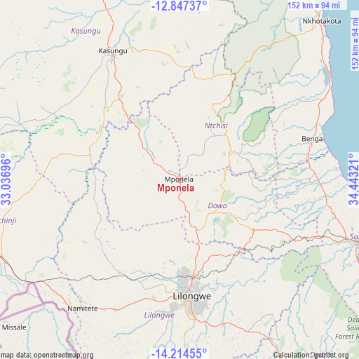
Mponela GPS coordinates[2]
13° 31' 54.984" South, 33° 44' 24.288" East
| Map corner | latitude | longitude |
|---|---|---|
| Upper-left | -12.84737°, | 33.03696° |
| Center: | -13.53194°, | 33.74008° |
| Lower-right: | -14.21455°, | 34.44321° |
| Map W x H: | 152×152 km | = 94.4×94.4mi |
| max Lat: | -9.70237° ⇑31.4% North |
| Mponela: | -13.53194° |
| min Lat: | ⇓68.6% South -16.91995° |
| min Long | Mponela | max Long |
| 32.88019° | 33.74008° | 35.65067° |
| W 11.4%⇐ | ⇒88.6% E |
Elevation
Elevation of Mponela is 1216 m = 3990 ft, and this is 347.3 m = 1139 ft above average elevation for this country.
| Max E: |
1608 m = 5276 ft | 20% |
| Mponela | 1216 m 3990 ft | |
| Avg. | 868.7 m = 2850 ft | |
Min E: |
55 m = 180 ft | 80% |
See also: Malawi elevation on elevation.city.
Geographical zone
Mponela is located in South Torrid zone (between Equator and Tropic of Capricorn). Distance of this Southern Tropic circle is 1101.3 km =684.3 mi to South.| Distance of | km | miles | from Mponela |
|---|---|---|---|
| Equator | 1504.6 | 934.9 | to North |
| Tropic Capricorn | 1101.3 | 684.3 | to South |
| Antarctic Circle | 5896.6 | 3664 | to South |
| South Pole | 8502.5 | 5283.2 | to South |


Nearby cities:
15 places around Mponela: (largest is in red/bold)
• Balaka
207.5 km =128.9 mi,  140°
140°
• Chipoka
98.2 km =61 mi,  121°
121°
• Dedza
113.8 km =70.7 mi,  145°
145°
• Dowa
25.3 km =15.7 mi, 122°
• Kasungu
62 km =38.5 mi,  333°
333°
• Likoma
195.3 km =121.4 mi,  33°
33°
• Lilongwe
48.6 km =30.2 mi,  173°
173°
• Mangochi
195.2 km =121.3 mi, 122°
• Mchinji
97.5 km =60.6 mi,  252°
252°
• Monkey Bay
141 km =87.6 mi, 115°
• Mzimba
182.1 km =113.2 mi,  355°
355°
• Nkhotakota
90.2 km =56 mi,  41°
41°
• Ntcheu
172.8 km =107.4 mi, 146°
• Ntchisi
18.9 km =11.7 mi,  88°
88°
• Salima
82.4 km =51.2 mi,  109°
109°
Sources, notices
• [Note1] Compared only with cities in Malawi existing in our database
• [Src1] Map data: © OpenStreetMap contributors (CC-BY-SA)
• [Src2] Other city data from geonames.org with taken over terms of usage.
• [Src3] Geographical zone / Annual Mean Temperature by Robert A. Rohde @ Wikipedia
