Dowa geodata
Dowa (Central Region) is a seat of a second-order administrative division; located in Malawi in Africa/Blantyre (GMT+2) time zone. With population of 5,565 people, there are 27 cities with bigger population in this country. Compared to other cities in Malawi, 65.7% of cities are located further ↓South; 74.3% of cities are located further →East and 94.3% of cities have lower elevation than Dowa. Note1


Dowa GPS coordinates[2]
13° 39' 14.364" South, 33° 56' 15.144" East
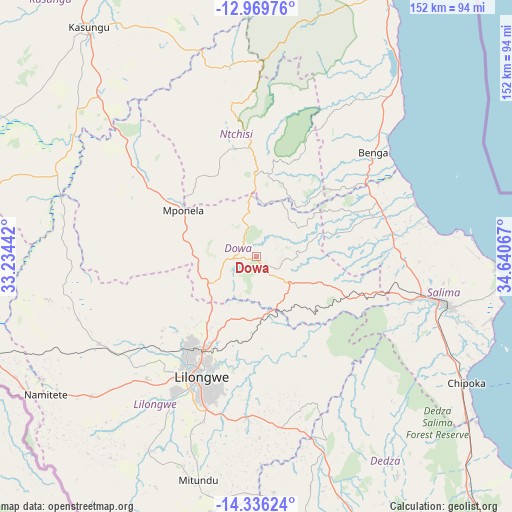
| Map corner | latitude | longitude |
|---|---|---|
| Upper-left | -12.96976°, | 33.23442° |
| Center: | -13.65399°, | 33.93754° |
| Lower-right: | -14.33624°, | 34.64067° |
| Map W x H: | 151.9×151.9 km | = 94.4×94.4mi |
| max Lat: | -9.70237° ⇑34.3% North |
| Dowa: | -13.65399° |
| min Lat: | ⇓65.7% South -16.91995° |
| min Long | Dowa | max Long |
| 32.88019° | 33.93754° | 35.65067° |
| W 25.7%⇐ | ⇒74.3% E |
Elevation
Elevation of Dowa is 1361 m = 4465 ft, and this is 492.3 m = 1615 ft above average elevation for this country.
| Max E: |
1608 m = 5276 ft | 5.7% |
| Dowa | 1361 m 4465 ft | |
| Avg. | 868.7 m = 2850 ft | |
Min E: |
55 m = 180 ft | 94.3% |
See also: Malawi elevation on elevation.city.
Geographical zone
Dowa is located in South Torrid zone (between Equator and Tropic of Capricorn). Distance of this Southern Tropic circle is 1087.7 km =675.9 mi to South.| Distance of | km | miles | from Dowa |
|---|---|---|---|
| Equator | 1518.2 | 943.4 | to North |
| Tropic Capricorn | 1087.7 | 675.9 | to South |
| Antarctic Circle | 5883 | 3655.5 | to South |
| South Pole | 8488.9 | 5274.8 | to South |


Nearby cities:
15 places around Dowa: (largest is in red/bold)
• Balaka
183.7 km =114.1 mi,  143°
143°
• Chipoka
72.9 km =45.3 mi,  121°
121°
• Dedza
91.1 km =56.6 mi,  152°
152°
• Kasungu
84.7 km =52.6 mi,  324°
324°
• Likoma
196.4 km =122 mi,  26°
26°
• Lilongwe
38.4 km =23.9 mi,  205°
205°
• Mangochi
169.9 km =105.6 mi, 122°
• Mchinji
115.3 km =71.6 mi,  261°
261°
• Monkey Bay
115.9 km =72 mi,  114°
114°
• Mponela
25.3 km =15.7 mi,  302°
302°
• Mzimba
198.4 km =123.3 mi,  349°
349°
• Nkhotakota
89.6 km =55.7 mi, 25°
• Ntcheu
149.9 km =93.1 mi, 149°
• Ntchisi
14.2 km =8.8 mi, 350°
• Salima
58 km =36 mi,  104°
104°
Sources, notices
• [Note1] Compared only with cities in Malawi existing in our database
• [Src1] Map data: © OpenStreetMap contributors (CC-BY-SA)
• [Src2] Other city data from geonames.org with taken over terms of usage.
• [Src3] Geographical zone / Annual Mean Temperature by Robert A. Rohde @ Wikipedia
